I was playing around with my cellphone, and in a fortuitous twist of timing, I managed to get the latest version of Google Maps for Android installed. Version 3.2.1 includes a few new features, with the one everyone's going crazy about being voice-driven GPS navigation. However, the one that I'm really enjoying works really nicely with my last post. You see, in earlier versions of Google Maps for Android, you could see Google Transit icons, but you couldn't get any information about them without actually plotting a trip. In this new version, you can. Push on any bus stop or train station, and it gives you the option to get transit, walking or driving directions there, or to view upcoming departures. Cool stuff.
Oh, a word of caution. To users with un-modified Android devices that aren't the Motorola Droid, this update won't install properly. The reason I've got it on my G1 is because I use a modified community-maintained firmware for my phone called CyanogenMod. It's freely available, and the process to convert your phone is well-documented, if a bit time-consuming. You can get more info on their web site.
By the way, 200th post!
Monday, November 30, 2009
Google Transit Geekiness
If anyone is in the habit of using Google Maps, you may have noticed that RTA's Google Transit data is now represented like the data from, well, every other transit provider out there.
Yes, that's right, RTA bus stops are now indicated at the appropriate zoom level in Google Maps. You can click on each and every bus stop in RTA's service area and see the lines that serve it, and the upcoming departures for each of those lines. Coolness!
Yes, that's right, RTA bus stops are now indicated at the appropriate zoom level in Google Maps. You can click on each and every bus stop in RTA's service area and see the lines that serve it, and the upcoming departures for each of those lines. Coolness!
Thursday, November 26, 2009
Happy Turkey Day
Greetings, loyal readers, and a most happy Thanksgiving to you all. I get the enviable joy of driving down CA-91 to Tyler street today- huzzah! If only there were some public agency out there that was tasked with transporting me... Hmmm...
Tuesday, November 24, 2009
Holiday Schedules
Hey everyone. The holidays are coming, and with them comes family, food, and bus closures! As a public service, I'm aggregating local transit agencies' holiday schedules right here on this blog.
RTA
RTA buses will not run on Thanksgiving (Nov. 26) and Christmas (Dec. 25).
RTA buses will run on Sunday schedules on New Year's Day (Jan. 1).
Omnitrans
Omnitrans buses will not run on Thanksgiving (Nov. 26), Christmas (Dec. 25) and New Year's Day (Jan. 1).
Metrolink
Metrolink trains are complicated, and organized by line.
Riverside, OC, Ventura, IE-OC and 91 Line trains will not operate on Thanksgiving (Nov. 26), Christmas (Dec. 25) and New Year's Day (Jan. 1).
Antelope Valley and San Bernardino Line trains will operate on Sunday schedules on Thanksgiving, including the usual service to Riverside.
Antelope Valley and San Bernardino Line trains will not operate on Christmas (Dec. 25).
Antelope Valley and San Bernardino Line trains will operate on a special New Year's Day schedule on New Year's Day (Jan. 1).
Amtrak
Amtrak Pacific Surfliner trains will operate on a weekend schedule on Thanksgiving (Nov. 26), Christmas (Dec. 25) and New Year's Day (Jan. 1), duplicating much of the service offered by the Metrolink Ventura and Orange County Lines.
OCTA
OCTA will operate on a holiday schedule on Thanksgiving (Nov. 26), Christmas (Dec. 25) and New Year's Day (Jan. 1). Check octa.net for details.
Office closures dot the holiday season, so be aware of that if you have business at any of the transit agency offices. Happy holidays!
Bicycle Roundabout
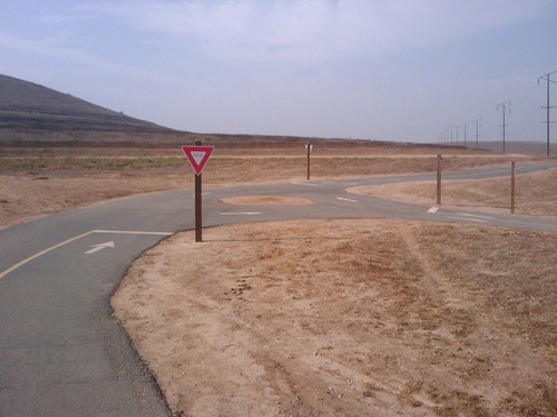
I like traffic circles, and I like bicycles, and so this has to be the coolest thing ever. It's a bicycle traffic circle, located on the Santa Ana River Trail near the Hidden Valley Nature Centre, about 3/4 of a mile short of the trail's current terminus in Norco. I make it a point to ride around it a few times every time I'm out this way.
Metrolink Delays Exaggerated by PE
The Press-Enterprise ran a story on recent Metrolink delays, which are apparently due to mechanical problems with the new MPXpress locomotives. Metrolink's on-time percentage has gotten down to 90%, from 95%, and riders have complained that, over the past six months, they have been late "a couple times." Of course, we should strive for reliability in our transit system, and I hope that Metrolink gets these issues worked out (fortunately the locomotives are still under warranty), but this sort of news coverage really irks me.
When I last held down a 9-5 job, I used to drive to work. (I eventually started riding the bus when I figured out how much I was spending on gas.) I was on time to work about 90% of the time. I was late more than a couple times over six months. I was late a couple of times over six months just due to stoplight timing or traffic issues. And my commute? A little over 4 miles. For the sort of people who would be using the train for long-distance commutes, an auto commute via our region's freeways would no doubt be substantially less reliable. This is an issue that no doubt needs to be worked out, but let's face it- sometimes the train is simply late. Similarly, sometimes tires go flat, cars crash, or CalTrans decides to close a lane out of random spite. Issues like this are parts of life, not an inherent weakness of Metrolink or transit.
When I last held down a 9-5 job, I used to drive to work. (I eventually started riding the bus when I figured out how much I was spending on gas.) I was on time to work about 90% of the time. I was late more than a couple times over six months. I was late a couple of times over six months just due to stoplight timing or traffic issues. And my commute? A little over 4 miles. For the sort of people who would be using the train for long-distance commutes, an auto commute via our region's freeways would no doubt be substantially less reliable. This is an issue that no doubt needs to be worked out, but let's face it- sometimes the train is simply late. Similarly, sometimes tires go flat, cars crash, or CalTrans decides to close a lane out of random spite. Issues like this are parts of life, not an inherent weakness of Metrolink or transit.
Monday, November 23, 2009
Demand, Choice, and New Urbanism
I was surfing about in the transit blogosphere last night when I came upon "Living Car-Free in Big D", a blog written by a car-free resident of Dallas, TX. As excellent as his blog is, I notice he feels pretty superior about pulling off a car-free life in a city like Dallas. Dude, at least you have light rail. But I digress.
Anyway, on trying to find the blog again this morning, I stumbled upon an article from a Dallas News blog about "Car-free in Big D", and I looked at the comments on the post. Here's a couple of choice ones.
These comments are posted in full and unabridged, lest I be accused of quote-mining. Blogs have theoretically infinite column-space, and I shall use it. Also, for context, Frisco, TX and Southlake, TX are Eastvale-style exurbs in the Dallas area. The commenter is not referring to South Lake, Seattle, WA or San Francisco, CA. CFiBD lives in Downtown Dallas, as anyone reading his blog will be made immediately aware.
These comments are pretty common reactions to anyone espousing the philosophy of New Urbanism, and I do consider myself a New Urbanist. We are accused of forcing people out of their cars,n of imposing our choice of transport on others, of making the inefficient transit systems of today the only option for transport. There are a number of misconceptions inherent in these criticisms, and I want to tackle them here.
First- New Urbanists do not seek to impose their transport or living arrangement choices on others, by and large. I think it would be nice if all private automobiles in the world were to suddenly be replaced by frequent transit service in livable communities, but I would never impose that on my fellow man. I don't want to see cars banned, though I may joke about it from time to time. (I also think this song is catchy.) What I want to see is people given the choice. I want to see communities where people can choose to live in dense, transit-oriented developments, or choose not to. I want to see local politicians and planners realise that density and diversity in housing is not a death knell for a community, that segregated-use zoning simply puts barriers between people and the things they want to buy and do in life, and that the structure of our built environment over the last 50 years is not something natural, but a consequence of policy and subsidy. I don't want to make you ride the bus, walk or cycle, but I want to be able to walk to the grocery store on safe sidewalks, cycle without being shouted at and run off the roadway, and ride transit without having to quintuple my travel time. And I am not alone, which leads me to the second point I want to make...
Demand. There is latent demand for vibrant, walkable and transit-served neighbourhoods. Some estimates I've seen (but, for the life of me, can't find to cite) say that around 30-40% of people would like to live in a dense, transit-rich neighbourhood, but only 15% of current housing stock actually qualifies as such. An analysis by CEOs for Cities found that every increase in WalkScore translated into an increase in home value between $700 and $3000 after controlling for other factors, with stronger effects for larger urban areas. This shows that people like to live in places where everything they need is in walking distance, and that they will pay accordingly. This shows that walkable (and therefore transit-friendly, in most cases) housing is in high demand, which (if you remember high school economics) indicates a low supply. I will note that this analysis did not hold in two of the 15 CSA's they studied, but that this rate of error was similar to that for the relationships between number of bedrooms and bathrooms and home price. For those who doubt the statistical validity of the results, as somebody who deals with regression analysis every single day at work, this looks very good.
Lastly, we come to the issue of how we propose paying for all of these improvements to transit and housing. First of all, even many conservative figures acknowledge that transit and dense communities are more fiscally sound. Cities get more property tax returns from dense development, as more value is concentrated in less land. And public transit projects facilitate substantial job creation, even more than road projects- 19% more according to USDOT. The California Transit Association estimates that, for every dollar spent on transit projects, three more dollars pass through local economies- and the Buy American policies that many local transit agencies have keeps that economic benefit here, rather than sending it to Toyota or Kia. Not to mention that transit customers, pedestrians and cyclists cost far less in terms of road maintenance. Transit-oriented development is not a heavily-subsidized social service, but a fiscally responsible policy that every community should examine.
There is, however, one thing that the car-dependent are correct about. Many New Urbanists expect drivers to bear the costs of providing transit service and encouraging TOD. I most certainly do. This is not because we wish to punish drivers, but rather because driving is presently heavily subsidized. The economic incentives are screwed up. Drivers pay less than 4% of the cost of the local roadways on which they drive, according the Victoria Transportation Policy Institute. This analysis doesn't even factor in the social costs of auto-dependence, such as pollution, loss of wild lands to sprawl, cost of hospital and ambulance services for car crash victims, lost years of life and human potential due to car crashes, war costs related to securing our oil supplies, war dead in conflicts to secure our oil supplies, the constraints imposed on our foreign policy because of the need for oil imports, the atrocities committed by oil companies enabled by state-side profits, and the list goes on. If these costs were factored in to the analysis, I doubt that drivers would come up with even 1 or 2% of the costs of their transportation.
As a transit user, my fares cover upwards of 18% of the costs of my transport. As a cyclist, I not only cover the cost of roadways through my sales taxes, but I subsidize the costs of other road users as well. If drivers were simply charged closer to the true costs of their transportation, many would choose other forms of transport simply for economic reasons, and states and municipalities would have more than enough money to run extensive transit services.
Of course, the costs of driving are getting worse, and they are going to keep doing so. As oil becomes ever-scarcer in our world (and have no doubt, it is), the cost of it is going to continue to increase. $15 a gallon is coming. I'm certain that many will change their preference for sprawling housing when that happens. We can either be prepared for this shift, with a robust transit system and zoning that permits dense, mixed-use development, or we can be caught clinging to the status quo, and people will be left with no choice but to spend $500 to fill their SUV's. I'd prefer the former.
Car people- please understand. We New Urbanists are not trying to force you into our way of life. We are trying to enjoy our way of life. We are trying to stop subsidizing things we don't agree with. We are only asking that you pay some of your fair share. If you paid the 20% towards roads that transit riders pay towards transit, our transit system would be in much better shape- and your roads would inevitably be emptier! We are not asking for conformity, only choice.
Anyway, on trying to find the blog again this morning, I stumbled upon an article from a Dallas News blog about "Car-free in Big D", and I looked at the comments on the post. Here's a couple of choice ones.
Posted by Hannibal Lecter @ 6:41 PM Mon, Nov 02, 2009
The problem with CFiBD is that he can't comprehend that not everyone wants to live exactly the same way he does. It's a kind of narcissism that seems to be endemic to bloggers. :-)
Too many of the "new urban" types just don't understand that people live in cities like Dallas specifically because they don't want to live in places like NYC. What they call "sprawl" is what many more people call "The American Dream".
Density: What everyone wants for the other guy's neighborhood.
Posted by MB999 @ 12:44 PM Tue, Nov 03, 2009
I don't understand why people continually whine "sprawl" as if we're running out of land in Texas.
Where do these socialistic liberals expect all these newcomers to the Metroplex to live? They want to force the average person into soviet 50 story government housing projects downtown or build some bleak crowded Bronx style urban ghetto type development and dependent on DART while the people whining about sprawl probably live in a place like Soutlake or Frisco.
DART is an inefficient and corrupt money pit. It takes three times as long to get to your destination using them vs driving. Most people prefer single family homes to apartment living.
Obama Socialists can't stand the freedom of movement that the automobile offers nor can they stand the idea of people living single family homes. They make up schemes and lies about "global warming", "running out of farmland", "sprawl" and want to herd people into places THEY want you to live and dependent on transit that THEY control.
These comments are posted in full and unabridged, lest I be accused of quote-mining. Blogs have theoretically infinite column-space, and I shall use it. Also, for context, Frisco, TX and Southlake, TX are Eastvale-style exurbs in the Dallas area. The commenter is not referring to South Lake, Seattle, WA or San Francisco, CA. CFiBD lives in Downtown Dallas, as anyone reading his blog will be made immediately aware.
These comments are pretty common reactions to anyone espousing the philosophy of New Urbanism, and I do consider myself a New Urbanist. We are accused of forcing people out of their cars,n of imposing our choice of transport on others, of making the inefficient transit systems of today the only option for transport. There are a number of misconceptions inherent in these criticisms, and I want to tackle them here.
First- New Urbanists do not seek to impose their transport or living arrangement choices on others, by and large. I think it would be nice if all private automobiles in the world were to suddenly be replaced by frequent transit service in livable communities, but I would never impose that on my fellow man. I don't want to see cars banned, though I may joke about it from time to time. (I also think this song is catchy.) What I want to see is people given the choice. I want to see communities where people can choose to live in dense, transit-oriented developments, or choose not to. I want to see local politicians and planners realise that density and diversity in housing is not a death knell for a community, that segregated-use zoning simply puts barriers between people and the things they want to buy and do in life, and that the structure of our built environment over the last 50 years is not something natural, but a consequence of policy and subsidy. I don't want to make you ride the bus, walk or cycle, but I want to be able to walk to the grocery store on safe sidewalks, cycle without being shouted at and run off the roadway, and ride transit without having to quintuple my travel time. And I am not alone, which leads me to the second point I want to make...
Demand. There is latent demand for vibrant, walkable and transit-served neighbourhoods. Some estimates I've seen (but, for the life of me, can't find to cite) say that around 30-40% of people would like to live in a dense, transit-rich neighbourhood, but only 15% of current housing stock actually qualifies as such. An analysis by CEOs for Cities found that every increase in WalkScore translated into an increase in home value between $700 and $3000 after controlling for other factors, with stronger effects for larger urban areas. This shows that people like to live in places where everything they need is in walking distance, and that they will pay accordingly. This shows that walkable (and therefore transit-friendly, in most cases) housing is in high demand, which (if you remember high school economics) indicates a low supply. I will note that this analysis did not hold in two of the 15 CSA's they studied, but that this rate of error was similar to that for the relationships between number of bedrooms and bathrooms and home price. For those who doubt the statistical validity of the results, as somebody who deals with regression analysis every single day at work, this looks very good.
Lastly, we come to the issue of how we propose paying for all of these improvements to transit and housing. First of all, even many conservative figures acknowledge that transit and dense communities are more fiscally sound. Cities get more property tax returns from dense development, as more value is concentrated in less land. And public transit projects facilitate substantial job creation, even more than road projects- 19% more according to USDOT. The California Transit Association estimates that, for every dollar spent on transit projects, three more dollars pass through local economies- and the Buy American policies that many local transit agencies have keeps that economic benefit here, rather than sending it to Toyota or Kia. Not to mention that transit customers, pedestrians and cyclists cost far less in terms of road maintenance. Transit-oriented development is not a heavily-subsidized social service, but a fiscally responsible policy that every community should examine.
There is, however, one thing that the car-dependent are correct about. Many New Urbanists expect drivers to bear the costs of providing transit service and encouraging TOD. I most certainly do. This is not because we wish to punish drivers, but rather because driving is presently heavily subsidized. The economic incentives are screwed up. Drivers pay less than 4% of the cost of the local roadways on which they drive, according the Victoria Transportation Policy Institute. This analysis doesn't even factor in the social costs of auto-dependence, such as pollution, loss of wild lands to sprawl, cost of hospital and ambulance services for car crash victims, lost years of life and human potential due to car crashes, war costs related to securing our oil supplies, war dead in conflicts to secure our oil supplies, the constraints imposed on our foreign policy because of the need for oil imports, the atrocities committed by oil companies enabled by state-side profits, and the list goes on. If these costs were factored in to the analysis, I doubt that drivers would come up with even 1 or 2% of the costs of their transportation.
As a transit user, my fares cover upwards of 18% of the costs of my transport. As a cyclist, I not only cover the cost of roadways through my sales taxes, but I subsidize the costs of other road users as well. If drivers were simply charged closer to the true costs of their transportation, many would choose other forms of transport simply for economic reasons, and states and municipalities would have more than enough money to run extensive transit services.
Of course, the costs of driving are getting worse, and they are going to keep doing so. As oil becomes ever-scarcer in our world (and have no doubt, it is), the cost of it is going to continue to increase. $15 a gallon is coming. I'm certain that many will change their preference for sprawling housing when that happens. We can either be prepared for this shift, with a robust transit system and zoning that permits dense, mixed-use development, or we can be caught clinging to the status quo, and people will be left with no choice but to spend $500 to fill their SUV's. I'd prefer the former.
Car people- please understand. We New Urbanists are not trying to force you into our way of life. We are trying to enjoy our way of life. We are trying to stop subsidizing things we don't agree with. We are only asking that you pay some of your fair share. If you paid the 20% towards roads that transit riders pay towards transit, our transit system would be in much better shape- and your roads would inevitably be emptier! We are not asking for conformity, only choice.
Sunday, November 22, 2009
Corona Transit Center Groundbreaking
You all saw RTA's invitation to the Corona Transit Center groundbreaking ceremony last Friday, both on this site and from RTA. I was there on Friday morning, and I want to note I didn't see anyone else from the community down there, so I figured I'd show you all what happened.
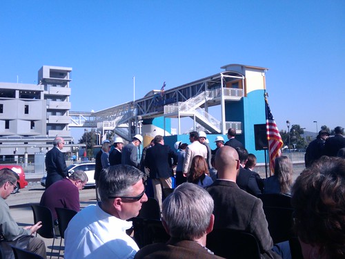
As I mentioned, it seemed like I was the only general member of the community, or of anything that might be called the media, at the ceremony. Everyone else was related to the City of Corona, RTA, RCTC, Metrolink, or one of the contractors on the project, but let me mention that that covers quite a few people. Essentially every major political player in local transportation politics was on site. A few of the notables included Assemblyman Jeff Miller (R-Corona), Corona Mayor Pro-Tem and RTA Board Chairwoman Karen Spiegel, Riverside Councilman and RTA Board member Andy Melendrez, long-time serving local politician and Norco Councilman Frank Hall, and numerous RTA board members from every jurisdiction running from Temecula to Calimesa to Banning. (Incidentally, Calimesa has no RTA service- why do they get a board member?) From the RTA staff, CEO Larry Rubio, Marketing Director Jim Kneepkens, Planning Director Mark Stanley, Communications Director Brad Weaver, and an assortment of other staffers. Notably absent, considering his name was on the invitation, was Congressman Ken Calvert (R-CA 44), who sent a representative from his office. He must've seen that I was coming, or perhaps he was too busy trying to stop health care for sick children again.
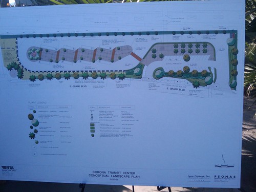
The actual presentations were a series of local politicians congratulating each other for this accomplishment, and were largely content-free. Proclamations were given, awards where exchanged, etc. I'll forgive this sort of behaviour, because it is not only the usual sort of thing with which politicians occupy their time, but it is, admittedly, a substantial accomplishment. That it took a decade or so to do isn't ideal, but I'm still glad it's been done. I will mention that I don't think Coronans are going to enjoy Ms. Spiegel's "world-class transit system", nor will this facility be "the premier transit facility in the state of California" as Mr. Rubio claimed, but I was heartened to hear her mention that the area around the facility has been zoned for transit-oriented development, and that the City of Corona is working with developers to install mixed-use housing around the site. I hope her understanding of transit-oriented development matches mine.
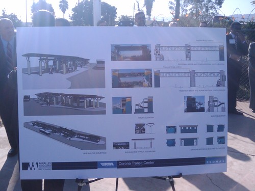
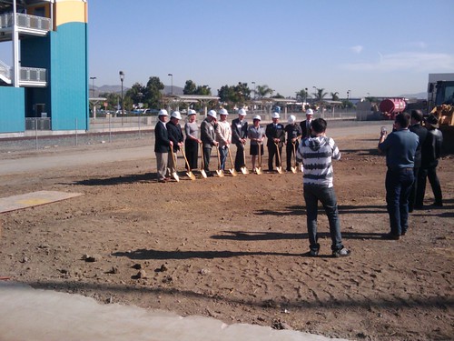
But enough about the ceremony- you folks want to know about the transit centre itself, I'm sure. It's slated to have 8 bus bays, a restroom for bus drivers, a 100' bus pullout at the street for Corona Cruiser routes, 26 new parking spaces and a bridge extension, connecting to the current bridge over the North Main-Corona Metrolink station. (It's interesting to note that, as of now, only 6 routes come even close to serving the transit centre- RTA 1, 3, 149 and 206, and Corona Cruiser Red & Blue. It will be a long time before this facility is over-capacity.)
Project engineer Travis Simison, with SeaWest Engineering, the centre's general contractors, says that the project is scheduled for completion in 40 weeks from this Monday, a total of 200 working days, which gives us an opening date in August or September, 2010. Personally, I'll be happy if it's done within a full year. Aside from the obvious benefits of the centre, it is expected to alleviate parking at the Park-And-Ride lot across the street, as customers will be able to use the under-utilized parking structure at the Metrolink. Of course, bringing these transit routes here also allows additional Park-And-Ride opportunities. Not the sort of thing I'm usually encouraging, but ridership is ridership.
I'd like to thank all the various local politicians and staffers who have made and are continuing to make this project happen. This centre will be an excellent addition to Corona's anemic transit system, and will hopefully help that system grow a bit. Corona Cruiser Green and Yellow routes, anyone?
I'd also like to mention that my concern for transit directions to the site seems to have been misplaced. There was one couple who walked to the actual ceremony site, but I suspect that they simply parked along the street. All other attendees besides myself drove there. I seem to have surprised many by arriving on a bicycle.
As I mentioned, it seemed like I was the only general member of the community, or of anything that might be called the media, at the ceremony. Everyone else was related to the City of Corona, RTA, RCTC, Metrolink, or one of the contractors on the project, but let me mention that that covers quite a few people. Essentially every major political player in local transportation politics was on site. A few of the notables included Assemblyman Jeff Miller (R-Corona), Corona Mayor Pro-Tem and RTA Board Chairwoman Karen Spiegel, Riverside Councilman and RTA Board member Andy Melendrez, long-time serving local politician and Norco Councilman Frank Hall, and numerous RTA board members from every jurisdiction running from Temecula to Calimesa to Banning. (Incidentally, Calimesa has no RTA service- why do they get a board member?) From the RTA staff, CEO Larry Rubio, Marketing Director Jim Kneepkens, Planning Director Mark Stanley, Communications Director Brad Weaver, and an assortment of other staffers. Notably absent, considering his name was on the invitation, was Congressman Ken Calvert (R-CA 44), who sent a representative from his office. He must've seen that I was coming, or perhaps he was too busy trying to stop health care for sick children again.
The actual presentations were a series of local politicians congratulating each other for this accomplishment, and were largely content-free. Proclamations were given, awards where exchanged, etc. I'll forgive this sort of behaviour, because it is not only the usual sort of thing with which politicians occupy their time, but it is, admittedly, a substantial accomplishment. That it took a decade or so to do isn't ideal, but I'm still glad it's been done. I will mention that I don't think Coronans are going to enjoy Ms. Spiegel's "world-class transit system", nor will this facility be "the premier transit facility in the state of California" as Mr. Rubio claimed, but I was heartened to hear her mention that the area around the facility has been zoned for transit-oriented development, and that the City of Corona is working with developers to install mixed-use housing around the site. I hope her understanding of transit-oriented development matches mine.
But enough about the ceremony- you folks want to know about the transit centre itself, I'm sure. It's slated to have 8 bus bays, a restroom for bus drivers, a 100' bus pullout at the street for Corona Cruiser routes, 26 new parking spaces and a bridge extension, connecting to the current bridge over the North Main-Corona Metrolink station. (It's interesting to note that, as of now, only 6 routes come even close to serving the transit centre- RTA 1, 3, 149 and 206, and Corona Cruiser Red & Blue. It will be a long time before this facility is over-capacity.)
Project engineer Travis Simison, with SeaWest Engineering, the centre's general contractors, says that the project is scheduled for completion in 40 weeks from this Monday, a total of 200 working days, which gives us an opening date in August or September, 2010. Personally, I'll be happy if it's done within a full year. Aside from the obvious benefits of the centre, it is expected to alleviate parking at the Park-And-Ride lot across the street, as customers will be able to use the under-utilized parking structure at the Metrolink. Of course, bringing these transit routes here also allows additional Park-And-Ride opportunities. Not the sort of thing I'm usually encouraging, but ridership is ridership.
I'd like to thank all the various local politicians and staffers who have made and are continuing to make this project happen. This centre will be an excellent addition to Corona's anemic transit system, and will hopefully help that system grow a bit. Corona Cruiser Green and Yellow routes, anyone?
I'd also like to mention that my concern for transit directions to the site seems to have been misplaced. There was one couple who walked to the actual ceremony site, but I suspect that they simply parked along the street. All other attendees besides myself drove there. I seem to have surprised many by arriving on a bicycle.
Tuesday, November 17, 2009
Street Life Frivolity
So this video is making the rounds of the YouTubes- an OfficeMax flash mob took over Union Square in NYC via subway and bus and did a huge dance routine in front of pleased onlookers.
This is the sort of frivolity that is enabled when you have vibrant street life. This particular example was enabled by a corporation, but ImprovEverywhere is all-volunteer and all-amazing, and mostly NYC. They're also the group responsible for the pantsless subway ride.
Aside from impromptu musicals, vibrant streets also enable such wonderful things as street musicians and street food. Steps from where that elf video took place, my friend and I sat for nearly half an hour and listened to an amazing jazz trio, at around 10pm. And street food? Most amazing thing ever. There is inexpensive, delicious food literally everywhere you turn in New York. And not just junk food- open-air fruit and veggie markets were liberally sprinkled throughout the city. Street food vendors are illegal in Los Angeles, and heavily regulated in Riverside.
The point is that walkable, transit-friendly spaces do more than just allow you to get from place to place- they allow you to enjoy a bit of culture on the way, something you'd never get while driving through.
Riverside now thinking about being bicycle friendly
The City of Riverside, at the end of last October, received yet another award. With the way the City spits out award press releases these days, Riverside residents and press seem desensitized to them, as this has received no coverage from the local press, but this is an award that actually matters. Riverside is now on the League of American Cyclists' list of Bicycle-Friendly Communities, as a Bronze-level community. This award recognizes the City's recently-renewed commitment to building bike lanes, the formation of a bicycle advisory committee, and the construction and maintenance of the Santa Ana River Trail. (It's too bad that the City can't force the construction of the rest of the trail through to the OC section- hopefully the county will get on that.) Congratulations to Riverside for being the first BFC in the Inland Empire.
The Bicycle-Friendly Communities award is designed to encourage local governments to continue improving cycling conditions in their communities. As of right now, many cycle lanes seem to disappear when extra auto lanes are required on city streets- see Central at Victoria, or 14th at Chicago. Both go from two lanes + a bike lane to 3 lanes without, with no warning. The City has an interactive map of bicycle pathways (the apparent source of the map I posted earlier) which shows a very massive proposed network of bicycle lanes, including all the way down both 14th and Central. Of course, when looking at proposals like this, you have to keep in mind that there are several competing interests in government, and the proposals of other offices may come in ahead of the bicycle plan, especially in the near future.
I also want to point out that bicycle safety education is one of the LAC's criteria for this award, and Riverside seems to be lacking in this area. While the RPD does, in fact, offer bicycle safety courses, the target of these courses is immediately apparent from even a cursory glance at their site. They offer bicycle training to children. The FAQ section on bicycle laws refers almost entirely to how children are expected to ride their bicycles. This is a very clear message- bicycles are second-class transportation choices, suitable for children until they reach 16 and can get their drivers' licenses. Notably, they offer no educational materials for drivers to learn how to interact with bicycles. We have made strides in bicycle-friendliness in the past years, but we have a long way to go.
P.S. Hi Mom!
Saturday, November 14, 2009
In the News
Your periodic update on local transportation news is here! I went trawling through the local paper for transportation news, and this is what I bring you.
Like the editorial board of the Los Angeles Times, and unsurprisingly, the Press-Enterprise seems to think that the construction of a new eastbound lane on SR-91 between SR-241 and SR-71 is going to magically make all that traffic go away. First off, SR-241-SR-71 is not a very long stretch. Second, induced traffic will quickly destroy any capacity gains on that freeway, ESPECIALLY on the 91. But lastly, and this is something to note- the lane will take TWO YEARS to complete, with a planned opening in 2011. Even the most car-happy can't look upon this project with approval- this means two years of construction (starting last Tuesday) on one of the most congested freeways in the country... for one measly lane, in one direction. Have fun with that, guys. I will be looking out the train windows and laughing, as I always do.
Oh, and did I mention? The project is going to cost $60m. I'd like to take this opportunity to remind you that RTA's annual budget is in the $40m region, including fare revenue. Orange and Riverside Counties just blew half again more than what it costs to provide bus service for 2500 square miles... on building a little under 5 miles of one lane, in one direction, on one freeway. That's $12m a mile. Let me just say that I would LOVE if our transit system got anywhere near the kind of money our road system does.
An inter-agency task force is working on transportation alternatives for the Big Bear area. Of course, I applaud this sort of work, but look at the alternatives being considered- "Metrolink rail, commuter rail, or aerial tramway"... First off, "Metrolink rail" is commuter rail, as I'm sure my readership knows, and aerial trams? What?
There are only two aerial tramways on this continent that operate in regular transit service- the Roosevelt Island Tramway in New York City, and the Portland Aerial Tramway in Oregon. Neither of these spans more than a mile. Even the longest tramway in the world, the tourist-driven Sandia Peak Tramway in New Mexico, is only 2.7 miles. Conservative estimates of the distance between Big Bear Lake and the valley floor range from 15 to 20 miles.
Incidentally, railway service to Big Bear is probably technically challenging at best. There is not, nor has there ever been, a rail line to Big Bear. (Wrightwood, on the other side of the Cajon Pass, did feature a line up Swarthout Canyon for hauling cattle and supplies in the early 20th century, but the tracks are long gone.) In fact, Big Bear's history as a resort turns upon the introduction of the second bus line in the world, the Mountain Auto Line- a fact I turned up in research which makes me want to go ride MARTA.
I applaud SANBAG's desire to find alternate transportation options for Big Bear tourists, but perhaps they should look at strengthening the transit service that's already in place rather than spending so much time on wild flights of fantasy.
Riverside County officials are "grappling" with the mandate of SB 375, a recently-passed law that requires cities to develop smart-growth policies to help the state meet its carbon emission commitments under AB 32, the landmark global warming legislation passed several years ago. Local officials are apparently concerned that the law removes local control over zoning and land-use decisions. While this law is a rather weak one, which leaves the actual development of smart-growth plans up to local government, it does, in fact, remove some local control over land use decisions. This is a good thing. Local governments will find it harder to justify sprawling tract housing developments and tarmac-covered strip malls, or at the very least, they will find it harder to give away our local tax dollars to developers in the form of fee waivers and variances, for vague promises of economic growth. Local governments, especially here in the IE, have made spectacularly bad decisions, and I trust Sacramento's vision for the future much more than i trust Hemet's.
Finally, the City of San Bernardino and SANBAG are going to destroy 15 homes for the benefit of automobiles. They're constructing new off-ramps at Tippecanoe off of I-10 that will essentially wipe an entire street off of the map. These aren't new off-ramps intended to serve a developing part of town- they're simply upgrades to existing off-ramps at the same spot. For that, 15 families will lose their homes. It's the same story that's been going since World War II- freeway construction is carried on for the benefit of middle- and upper-class commuters, while the homes of poor families (and especially those of people of colour) are demolished to make way. Our urban centres, such as they are, are destroyed for the benefit of traffic flowing from far-flung gated exurbs.
There's unfortunately little for the people of Rosewood Dr. to do. Laws ranging from municipal ordinances to the Constitution of the United States are on the side of city government. In Kelo v. City of New London, the Supreme Court cast a very broad interpretation of "public benefit", essentially asserting that anything that might conceivably be argued to have some broader public purpose is fair game for eminent domain. Under Kelo, a freeway off-ramp is remarkably beneficial- the City could (hypothetically, and IANAL) have demolished those 15 homes and erected a Councilman-only golf course on the site, under the argument that it would benefit the public by inspiring the ambitious to run for office. I hope that our government helps these people with their mortgages, but I don't hold out much hope.
Of course, the ultimate irony of the story? In this clear case of cars-vs.-people, one of the displaced local residents is photographed beside, not her home, but her SUV.
Friday, November 13, 2009
Coachella Valley Commuter Service
I caught a story in the Desert Sun today about RCTC's new feasibility study of a Coachella Valley commuter rail service, with a daily round trip to Los Angeles. Here's the frustrating thing, though- the Coachella Valley had the next best thing to commuter rail service. The SunLink express bus, offered by SunLine transit, ran several trips per day in each direction, traveling from Palm Springs to Riverside (Metrolink and bus terminal) via Beaumont Wal-Mart. It was provided with a sort of vehicle that I have not seen before or since, a tractor-trailer combination that offered Metrolink-like seating and an on-board restroom. (I found out doing research for this post that these are called "SuperBuses" and ran on several OCTA express routes in the 80's and 90's before moving to SunLine. A photo of one that remains at OCTA's Irvine yards here.) It was canceled back in 2004, and as of now there is no public transit link between the IE and the Coachella Valley, though Amtrak and Greyhound do provide some limited service. (RTA 210 now provides the Beaumont-Riverside route.)
According to The Transit Coalition's Nicholas Ventrone, SunLink managed to garner "productive ridership" before it was canceled in 2004. Train lines, especially to never-served areas, take time to construct, but express buses can go from planning to passengers in the time it takes to put up the sign posts and print the schedules. Let's do something about Palm Springs commuters *now*, and then worry about rail service later.
P.S. According to a 2002 description by the Southern California Transit Advocates, SunLink had coffee and tea on board for a nominal charge. Amenities like this would go a long way towards attracting commuters- the morning coffee run that many make could be accomplished while still in motion. RTA sells the Press-Enterprise on board some CommuterLink routes, and that's a start.
Tuesday, November 10, 2009
Hurricane drenches millions, inconveniences drivers
Automobile dominance was on display in my GMail inbox today, and not in an advertisement. Google's "Web Clips" service often brings Reuters headlines across the top of my e-mail, and this one graced that space this morning:
"Weaker Ida drenches US Gulf Coast, hits oil supply"
Yes, that's right. Millions of people are threatened with flooding, 60M/h+ winds, and torrential rain. The governor of Louisiana has declared a state of emergency. Lives may be lost, and property will most certainly be damaged- and the most important aspect of this storm that the world needs to know about? How it affects oil prices.
Folks, even the 43rd President of this country, who was oblivious to pretty much everything else, acknowledged our nation's addiction to oil. When the ex-oil company executives start admitting there's a problem, you know there's a problem. And, of course, the elephant in the room that nobody will talk about- we are addicted to oil because we are addicted to driving. This has to stop.
Monday, November 9, 2009
Meeting in Review
Tonight, RTA held a community meeting on the restructuring of routes 29, 49, and 149. I was there- alone again. I've just come from that meeting, and am now sitting at Mumbles Frozen Yogurt (on University between Iowa and Cranford, served by 1, 16, 25, 51 and 53, inexpensive and delicious) enjoying their free wi-fi and blogging for you all.
Routes 29 and 49 are scheduled to be interlined on January 10, 2010. Both routes are going to see an extension of service span- the 29 by 50 minutes and the 49 by 20 minutes- and a reduction in service frequency- both to 70 minutes, from the 29's current 65 and the 49's current 50. This is, unfortunately, going to mean more waiting for passengers in Rubidoux, Pedley and Mira Loma, but it also means later service times, with the 49 (ending at 8:28) approaching the 9:00 service standard for directly-operated regional routes. Neither route was exactly frequent to begin with, and this reduction will mostly result in the inconvenience of learning a new schedule. RTA officials hope to increase frequency on both routes when the budget situation improves.
Route 149 will not be changing much. It will be re-numbered the CommuterLink 216, but agency officials assured me that the unique character of the route- including weekend service and interlining with Route 1 for the last run of the night- will be preserved. They will be running 40-foot CommuterLink buses on the route (I didn't know they had those!), and so capacity will also remain the same. The only thing changing is the fare structure, to become more consistent with the rest of the system. I welcome this change, and enjoy watching the demise of the special only-for-this-route fare grid.
Other changes are coming to the system. Routes that currently serve the 4th & Wilkerson transfer point in Perris are being re-routed to serve the new Perris Multi-Modal Transit Centre. 1, 13, and 15 are being detoured around the Magnolia bridge construction- 1 and 15 via Jurupa, Brockton and Beatty, 13 via Jurupa, Riverside and Central. The alternate routing of 21 to Parkview Hospital will be discontinued, increasing both service span and frequency on that route.
I would like to mention to my readers in 29/49 country- RTA is NOT planning to hold community meetings in your area. If you would like to voice your opinion, you may do so via snail mail at:
Planning Director
Riverside Transit Agency
PO Box 59968
Riverside, CA 92517-1968
or via e-mail at GetOnAndGo@RiversideTransit.com
or in person at the next Board Meeting, Thursday Nov. 19th at the County Administration Building (a short walk from the Downtown Terminal) at 2pm. The fact that Agency officials did not see fit to hold a community meeting in the affected communities is disheartening, but probably pragmatic, considering the sort of attendance these meetings usually attract.
Still, I encourage all of you to make sure your voice is heard.
Sunday, November 8, 2009
Car-Free in the Suburbs
I was reading through a discussion on the MetaFilter boards about car-free cities in Europe, and their relevance to urban planning in the US. One thing that keeps coming up over and over and over is that car-freedom is only possible in a handful of places in the US, with New York City usually cited as #1. Other posters brought up the central cities of Portland, San Francisco and Philadelphia. Nobody said that car-freedom was even remotely possible in suburban areas.
Now, I know that there are vast tracts of Riverside where car-freedom is truly impossible. It took me all of five minutes to find a spot in the city with a WalkScore of 22. WalkScore says that the city's average is 49, which is still rather car-dependent. However, my house ranks a 72. Some parts of downtown cross 90. I spent the entire summer car-free and I still managed to live a very full life out here in the suburbs. Is it harder to do so here, where we have no (local) rail transit and the bus system is often sub-par? Sure. I'll say it certainly requires a bicycle. But car-freedom is possible even in certain places in the suburbs, if you're willing to put in a little time and effort.
So why is it that more people don't go car-free in the suburbs? It's not because car-freedom is harder- it is, but not significantly so, especially for a cyclist. It is because car ownership is so much easier. Most apartments come with two parking spaces, and often a garage. Free parking is abundant, roads are wide and high-capacity, and the built environment encourages automobile travel. A key point that we have to drive home as transit advocates is that, to make our towns and cities more transit-friendly, we have to make them less car-friendly. Closing roads, charging market rates for parking, and other measures that allow us to lessen the external costs of automobiles are key parts of improving our neighbourhoods and quality of life.
I want to make clear that I'm not necessarily anti-car. I own a car. However, car drivers need to understand that driving is extraordinarily cheap right now (and highly subsidized- nearly 96%, compared to 80% for RTA and 50% for Metrolink), and they need to be willing to help pay for the destructive effects of their choice of transportation. We can either gradually increase the cost of driving, or we can wait until the inevitable environmental and geopolitical effects of our automobile addiction catch up with us, and drastically raise the price of driving naturally. If we start now, we can put some of these increased costs towards the alternatives which will eventually replace the automobile. If we wait, we will be left with no real opportunity to drive, and no real alternatives to driving.
Saturday, November 7, 2009
Bikeway Map
Hello everyone. I got a map of all of Riverside's bike pathways at Anthony's Cyclery while picking up a new tube for my bike, so I wanted to share it with you all.
On this map, Class 1 and Class 2 bikeways are indicated. Class 1 bikeways are paths that are exclusively for various forms of non-motorized transportation, including bicycles. Class 2 bikeways are bike lanes along roadways. The path down Victoria Avenue is a mix of both, and is indicated on the map as "Class 1 & 2".
I hope this map will be useful in your travels.
UPDATE: I've modified the map slightly, adding a "Major Bus Station" icon at the Tyler Mall and an icon for the Pedley Metrolink station, both of which were improperly omitted from the map.
A hint for OCTA planners
So I spotted this piece on the LA Times blog site. Apparently it is the opinion of the LA Times metro staff that the 91 freeway through the Santa Ana River canyon is going to be improved by a new widening project. They're adding a lane in each direction.
Apparently nobody at OCTA has read the seminal 1998 UC Berkley study* that showed, using data from 30 years of California traffic, that adding lanes to freeways is a net loss in time- the time saved by the addition of new lanes will never add up to the time lost during the construction of those lanes, because of the phenomenon of "induced traffic." We can't pave our way out of traffic problems- it simply doesn't work.
If you want to relieve traffic on the 91 run through the canyon, here's a brilliant idea- give commuters a choice. Current transit service is limited to Metrolink, which is largely tailored to long-distance travelers, and is limited mainly to commute-hour service (the 91 Line, which parallels its namesake freeway, is among the most limited in the system, with no off-peak or reverse-peak service whatsoever), and two express bus lines- the OCTA 794, which just got disconnected from the rest of the bus system, and is peak-hour-peak-direction only, and the RTA 149, which is largely peak-hour only, at least on weekdays. (It's strangely more flexible on weekends.) Provide the thousands of daily 91 drivers with an honest choice of transportation options, with all-day, daily transit service through the canyon, via the 91 Express Lanes, and I bet you would see significant ridership and traffic relief. And it would be much cheaper than adding another lane to an already bloated freeway.
A quick primer on induced traffic and the paradox of freeway widening can be found here.
* Donald D.T. Chen. "If You Build It, They Will Come…Why We Can't Build Ourselves Out of Congestion." Surface Transportation Policy Project Progress VII.2 (March 1998): I, 4.
Friday, November 6, 2009
We did it first!
So apparently San Antonio, TX's VIA bus service is going to start offering WiFi on several express routes in a pilot program to see if folks will use it. Also, Amtrak is considering offering WiFi on the Acela Express service between DC and Boston. (Amtrak used to offer such service on the Capitol Corridor between San Francisco and Sacramento, but hasn't done so on any California service trains since then.) I just want to mention that Riverside Transit has had on-board wi-fi on the CommuterLink 202 since 2005, along with satellite TV.
I think it's great that other transit agencies are starting to follow RTA's lead on this one. I'm also glad RTA has taken the lead. Hopefully they'll expand their offerings to routes other than the 202- I'd love to surf the 'net on a long trip on the 1 down Magnolia.
I think it's great that other transit agencies are starting to follow RTA's lead on this one. I'm also glad RTA has taken the lead. Hopefully they'll expand their offerings to routes other than the 202- I'd love to surf the 'net on a long trip on the 1 down Magnolia.
Thursday, November 5, 2009
It gets dark fast now!
With the irritatingly late time change (Seriously, can't we get rid of Daylight Savings already?), I thought it was time to share with everyone some points about alternative transportation and darkness.
Cyclists!
Take this opportunity (yes, you, now) to go change the batteries in your blinky lights. If you don't have a blinky light, go get one. Also take the time to make sure all of your reflectors are on and intact.
When you're out there riding, be sure to ride where you're supposed to ride. That's where motorists and pedestrians will be looking for you. This means stick to the bike lane, and ride with traffic. No bike lane? Use the right-hand traffic lane, and stay away from those opening car doors.
Transit riders!
Try and find a well-lit bus stop if you're going to be waiting a while. I've never been robbed waiting for a bus, but I have been robbed. It's not a fun experience, and it was somewhere dark.
If you're concerned about being passed up, try a trick I use when I'm waiting for a bus at night- use the display backlight of your cell phone to wave down the bus. This is especially good if you're wearing dark clothing.
Walkers!
Stick to the sidewalks where you can, wear bright clothing, and cross at a crosswalk. I rarely drive, and I still sometimes come close to running somebody over because they're jaywalking across University in a stunning all-black outfit.
Similarly, if you have to walk dangerously close to traffic, either a bicycle blinky or your cell phone display backlight can be used for that extra bit of visibility.
Remember, it's still a car-dominated world. Protect yourself from all the speeding metal death.
Wednesday, November 4, 2009
Action!
I posted yesterday on RTA's invitation to the Corona Transit Centre groundbreaking, and its notable lack of transit directions in favour of automobile directions to the ceremony site. Well, I also e-mailed them about the issue, and RTA Marketing Director Jim Kneepkens e-mailed me this morning to inform me that the omission had been corrected, and indeed it has been. Thanks for the change, guys, and I hope you'll keep this in mind in the future.
Dial-A-Ride Changes
I have not yet commented on the upcoming changes to RTA's Dial-A-Ride policy. I am not an RTA Dial-A-Ride patron, and so I can't provide a full explication of how such changes will affect current riders. I don't know, for example, how often RTA currently exceeds the 3/4 mile envelope of fixed-route service for their riders. I know that this 3/4 mile boundary is not RTA's policy- it is federal policy, and transit agencies across the country provide service at such a limit. I also can't comment on the vagaries of current ADA qualification policy, as I've never had to go through such a process. For these reasons, I was not going to comment on the upcoming DAR policy changes, but riders have e-mailed me with concerns about losing their transportation services, and so I write this post today in order to ease their concerns.
The following are the changes to DAR policy that will be implemented next January. (I took this text directly from the RTA brochure):
Here's a few things that will NOT happen, come January.
If you are disabled, you will NOT lose your DAR eligibility because of your age. If you're currently riding as a senior because you don't want to go through the DAR registration process, you will probably want to go through that process soon.
If you currently ride on the City of Riverside's Special Transportation minibus service, NOTHING about your service will change. This system will continue to transport passengers above the age of 60. Similarly, eligibility requirements for Corona, Banning and Beaumont Dial-A-Ride services are not changing. (Incidentally, Corona offers Dial-A-Ride service to all city residents. This, I did not know.)
If you take short-to-medium-length trips on Dial-A-Ride, your fares will probably NOT change. RTA's fare-zone system is intended primarily to offset the costs of providing transportation to riders that, at present, can traverse the entire service area for $3. RTA's service area is the second-largest in the nation, behind only Denver's Regional Transit District. It stretches from Grand Terrace to Temecula, with express routes from Montclair to Escondido. It only makes sense that the agency charge more for long trips.
RTA staff showed a lot of graphs at the Board meeting, when this issue was voted on. They weren't pretty graphs. In a couple of years, RTA would have had to start cannibalizing their fixed-route service to continue to provide the level of Dial-A-Ride service they currently do. These changes aren't great, but they are necessary in these budgetary times. Perhaps FY2010 or FY2011 will prove to be better for the agency, but for now, these policy changes are a matter of survival for our local transit operator.
So I hope this clears up some of the doom-and-gloom that's been going around about these changes. If you are affected, I encourage you to contact RTA's Dial-A-Ride people
The following are the changes to DAR policy that will be implemented next January. (I took this text directly from the RTA brochure):
- Enforce a strict 3⁄4 mile boundary policy: DAR vehicles will no longer, under any
circumstances, travel to areas outside three-quarters of a mile of an RTA local fixed
route even if we provided service to that location in the past. In addition, service
will only be provided during the hours of complementary fixed-route operations. - Shorten reservation window from seven days to three days in advance: A shorter
reservation window will reduce no-shows and boost service productivity. - Enforce trip-by-trip and conditional eligibility: For passengers with restricted
eligibility under ADA status, trip requests will be subject to individual case review. - Raise the age for local senior DAR eligibility from 60 to 65. Qualified disabled
seniors under 65 may still qualify for ADA priority service. - Create a zone-based fare system: Per federal regulations, the cost to ride on DAR
can be no more than twice the cost of a fixed-route trip. However, in many cases,
RTA has not been charging the full fare for DAR trips that cross multiple fixed-route
zones. Beginning January 10, DAR customers will be subject to paying additional
fares on trips that exceed one comparable fixed-route zone, with a maximum fare
per trip of $9.
Here's a few things that will NOT happen, come January.
If you are disabled, you will NOT lose your DAR eligibility because of your age. If you're currently riding as a senior because you don't want to go through the DAR registration process, you will probably want to go through that process soon.
If you currently ride on the City of Riverside's Special Transportation minibus service, NOTHING about your service will change. This system will continue to transport passengers above the age of 60. Similarly, eligibility requirements for Corona, Banning and Beaumont Dial-A-Ride services are not changing. (Incidentally, Corona offers Dial-A-Ride service to all city residents. This, I did not know.)
If you take short-to-medium-length trips on Dial-A-Ride, your fares will probably NOT change. RTA's fare-zone system is intended primarily to offset the costs of providing transportation to riders that, at present, can traverse the entire service area for $3. RTA's service area is the second-largest in the nation, behind only Denver's Regional Transit District. It stretches from Grand Terrace to Temecula, with express routes from Montclair to Escondido. It only makes sense that the agency charge more for long trips.
RTA staff showed a lot of graphs at the Board meeting, when this issue was voted on. They weren't pretty graphs. In a couple of years, RTA would have had to start cannibalizing their fixed-route service to continue to provide the level of Dial-A-Ride service they currently do. These changes aren't great, but they are necessary in these budgetary times. Perhaps FY2010 or FY2011 will prove to be better for the agency, but for now, these policy changes are a matter of survival for our local transit operator.
So I hope this clears up some of the doom-and-gloom that's been going around about these changes. If you are affected, I encourage you to contact RTA's Dial-A-Ride people
Tuesday, November 3, 2009
RTA and the Car Culture
Okay, so RTA managed to anger me today. I was looking on their web site, and I noticed an invitation to the Corona Transit Centre groundbreaking ceremony. (I've already RSVP'ed.) So I downloaded the invitation, and it provides the following directions to the ceremony site:
That's all.
The directions, provided by a transit agency, to the groundbreaking ceremony of a transit centre, which happens to be served by several bus routes (RTA 3 and 149, Corona Cruiser Red & Blue) and Metrolink service, are driving directions only.
RTA, listen. You have a responsibility to help ease the automobile's grip on society, as our local transit provider. You have a responsibility to provide access to your events to everyone, and you of all people should not discriminate against those who use YOUR services. Where do you think all of the political and social roadblocks to your agency come from? They come from the car culture that dominates our society, and it's not just a good idea that you ought to help alleviate that- it's in your political interest, as well. I've gotta say, I'm disappointed.
For anyone who plans on attending the transit centre groundbreaking, some directions:
FROM WITHIN CORONA: RTA Route 3 provides service along Main north of 10th. Other passengers, use the appropriate Corona Cruiser route. Both Red and Blue stop near the ceremony site.
FROM RIVERSIDE: RTA Route 149 serves the ceremony site directly, departing from both the Downtown Terminal and Tyler Mall. If you would rather not wait around for two hours, take RTA Route 1 to 6th & Main and walk up Main the ~3/4m to the ceremony site, or transfer to Route 3 or the Corona Cruiser at 6th & Main. Metrolink also serves the site.
FROM LAKE ELSINORE/TEMECULA/MURIETTA: RTA Route 206 serves the ceremony site directly.
FROM ELSEWHERE IN SOUTHERN CALIFORNIA: Ride Metrolink to the North Main-Corona station, which is ceremony-adjacent.
FROM INTERSTATE 91: Exit North Main Street, go north, turn right on East Grand Boulevard.
Entrance to the transit center will be on your left.
FROM INTERSTATE 15: Take Interstate 91 West, exit North Main Street, go north, turn right on
East Grand Boulevard. Entrance to the transit center will be on your left.
That's all.
The directions, provided by a transit agency, to the groundbreaking ceremony of a transit centre, which happens to be served by several bus routes (RTA 3 and 149, Corona Cruiser Red & Blue) and Metrolink service, are driving directions only.
RTA, listen. You have a responsibility to help ease the automobile's grip on society, as our local transit provider. You have a responsibility to provide access to your events to everyone, and you of all people should not discriminate against those who use YOUR services. Where do you think all of the political and social roadblocks to your agency come from? They come from the car culture that dominates our society, and it's not just a good idea that you ought to help alleviate that- it's in your political interest, as well. I've gotta say, I'm disappointed.
For anyone who plans on attending the transit centre groundbreaking, some directions:
FROM WITHIN CORONA: RTA Route 3 provides service along Main north of 10th. Other passengers, use the appropriate Corona Cruiser route. Both Red and Blue stop near the ceremony site.
FROM RIVERSIDE: RTA Route 149 serves the ceremony site directly, departing from both the Downtown Terminal and Tyler Mall. If you would rather not wait around for two hours, take RTA Route 1 to 6th & Main and walk up Main the ~3/4m to the ceremony site, or transfer to Route 3 or the Corona Cruiser at 6th & Main. Metrolink also serves the site.
FROM LAKE ELSINORE/TEMECULA/MURIETTA: RTA Route 206 serves the ceremony site directly.
FROM ELSEWHERE IN SOUTHERN CALIFORNIA: Ride Metrolink to the North Main-Corona station, which is ceremony-adjacent.
Sunday, November 1, 2009
1 Million Riders!
For anyone who doubted the effectiveness of RTA's free ride programs for college students, check out this piece in the PE. RTA just celebrated 1 million riders from their RCC U-Pass program. Note- that's JUST the RCC program, though admittedly it has been the most successful of the college pass programs. The agency sees 80,000 boardings a month from community college students. This is a phenomenal program that provides access to transportation and education for thousands. Bravo, RTA.
Subscribe to:
Posts (Atom)

