Since we're on the topic of California's planning and development processes, I think I'll take the time to talk about another pet peeve of mine: the misappropriation of transit and air-quality improvement funds to fund automobile projects. This problem is endemic throughout suburban America, and a great number of recent projects in Riverside highlight the issue. The Magnolia Ave. grade separation, for example, was paid for in part by funding received by the city for air quality improvement. (The City of Riverside portion is CMAQ funds.) The Colton Crossing project was sold in part by referring to the benefits it would bring to transit users, although only 7 passenger trains a day (compared to hundreds of freight trains) use that particular section of rail. While funding documents for the upcoming SR-91 HOV project are not yet easily accessible on the Internet, the benefits to transit customers are already being touted by project boosters- despite the fact that only 5 buses a day in each direction will use the lanes. The entire SR-91 Improvement Project, which will cost several hundred million dollars, will be used by only 10 buses in each direction per weekday, and only 4 on weekends. Making it easier to drive will, of course, only lead to increased congestion and the withering of alternative transportation.
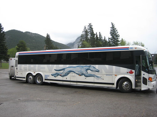
The project that prompted this post, however, is a particularly egregious example. It's not located here in Riverside, but in Baldwin Park. The San Gabriel Valley Tribune reports on the City of Baldwin Park's plans to build a "transit center" adjacent to the present Metrolink station. (I should mention that, as a station on the San Bernardino line, the Baldwin Park Metrolink enjoys some of the most frequent service in the system.) After reading the article, however, I got the impression that this new "transit center" was only tangentially related to transit. The article gushed over the brand new, 500-stall parking structure that would be linked to the train station, and lamented the plight of commuters who currently have to walk two whole blocks to park their personal vehicles (for free!) and access the train. I thought that this might have simply been local media bias, however, so I checked out the project documents. Perhaps there would be an improved bus terminal, or some other improvement worthy of the "transit center" name.
As I feared, the project will add very little in the way of actual improvements to transit service in the area, besides train-adjacent parking. A few bike racks and a possible bus driver's restroom, as well as a transit information kiosk, will be added. Bus riders will still be dropped off on the street, and those unlucky enough to be heading westbound will have to find somewhere to cross the street to access the new pedestrian bridge. (No pedestrian traffic signal is indicated in the project documents.) Also, of the six levels of parking, the project documents suggest that only two will actually be dedicated to transit users.
I don't have anything against park-and-ride facilities per se, and they do serve a purpose in getting regular work commuters on to specialized commuter transit. However, funding for our transit systems is scarce. Park-and-ride facilities actually undermine the goals of local transit agencies, as they allow commuters to take advantage of the benefits of transit for their work trip, while incentivizing their auto use for all other trips they make. Our cities should be focusing on transit projects that reduce automobile dependence, rather than cementing it.
This project is being paid for by a Federal Transit Administration grant, but it is a lot more about getting a sparkly new downtown parking garage for the City of Baldwin Park than it is about transit.
Wednesday, December 21, 2011
Tuesday, December 20, 2011
Vehicular Cycling and the Suburbs
Brown Girl in the Lane has a scathing critique up about vehicular cycling advocates. While I'm not about to say a word about her concern for the diversity of cycling, and the overwhelming white-male-ness of long-time vehicular cycling advocates, I want to push back against some of what she is saying. It's true that, in a perfect world (or Denmark), we'd have plentiful, grade-separated bicycle paths along every major road, and that bikes would be treated with respect by cars on the low-speed roads where they mix. Sadly, this is not a perfect world, and bicycle infrastructure is often severely lacking, especially out in the suburbs. (Riverside is actually on better footing than many surrounding cities, but this is still the case here, especially outside of downtown and the University area.) Vehicular cycling is a valuable tool for maintaining a cyclist's safety under specific infrastructural conditions, when a road leaves provision for cars and nothing else. Our right to the road, codified in CVC 22201(a) 21202(a), is an important tool to be used when city planners have neglected our right to safe passage in the public right-of-way.
For example, I'm going to go back to a long-standing pet peeve of mine in Riverside's bike infrastructure: Arlington Ave. between Indiana and Magnolia. Vehicular travel lanes are 10 feet wide, two in each direction. There is no shoulder, and no parking lane. Sidewalk cycling is illegal in Riverside, and is in any case rather dangerous due to driveway traffic. There are no alternate routes along side streets, as every street ends at the 91 freeway except the major arterials. (Central Ave. is even worse.) Oh, and did I mention that this is a City-designated bike route?
View Larger Map
(A quick map, so you can see that there really are no good cycling routes through here.)
View Larger Map
(And a street-level view. This passes for a "class III" bike route in Riverside.)
So I've recently taken up climbing at the Hangar 18 climbing gym, which is right next to the airport on Arlington. My choices are either to travel through this area or go several miles out of my way. I chose today to take the lane- and yes, it's not fun. Cars speed by you, honk, yell at you, etc. But if I were to ride at the far right-hand side of the lane, they would speed by much closer, and put me in greater danger than I currently am. The skill of vehicular cycling allows me to navigate sub-par infrastructure safely, while I continue to advocate for safer cycle routes.
Wherein I Agree with New Geography
New Geography is a blog that I occasionally read, mostly because it's on Straight Outta Suburbia's excellent blogroll. They're a conservative blog, and their narratives often run counter to the urbanist paradigm. (It goes without saying that our interpretations of empirical data often are in disagreement as well.) Suburban booster Joel Kotkin, frequent columnist at Reason, is the blog's founder. Thus, it's odd that I find myself in agreement with one of their recent posts, although for slightly different reasons.
In "California: Codes, Corruption and Consensus," blogger Bill Watkins asserts that the California planning and environmental review process is profoundly broken. The long list of "stakeholders" that must be consulted to get damned near anything built, he says, allows for corruption and introduces uncertainty for developers and businesses. Furthermore, the effective veto held by a long list of groups makes it very difficult to build even the most uncontroversial of projects.
The current system for development is undoubtedly an impediment to a great many goals. Watkins wants to streamline the process in order to reduce cost and uncertainty for business. I'd like to see the corruption that results from the process-- visible in the way many megacorporations can get municipalities to waive taxes, fees, and environmental reviews, while small businesses and residents have to pick up the slack in revenue-- significantly reduced. Furthermore, the effective veto held by any "stakeholder" in the area over major projects is a significant impediment to much-needed density and transit improvements. (See, for example, the effect the University Neighborhood Association's opposition has had on the Perris Valley Line, or Beverly Hills School District's opposition to the urgently-needed Subway to the Sea.)
Fortunately, the solution Watkins proposes is amenable to urbanism as well, if done carefully. He proposes that projects that substantially conform to regional and community plans be assured rapid completion. The time for community input (read: opposition) would be during the development of the plan, rather than during the development of a specific project. Not only would this reduce the overall cost and delay of opposition and lawsuits, as NIMBYs would have only one process to disrupt rather than several, but such a review would also allow for the complete reassessment of a community's character and development at a single point in time. Such an opportunity could allow a coherent, urbanist vision of a community to prevail over the present, sprawl-creating zoning systems (which currently continue largely out of institutional inertia, rather than merit.)
Of course, streamlined development review would not singlehandedly allow the accomplishment of urbanist objectives, and I have no doubt that the usual suspects would struggle against the proposal of any increase in density or shift towards sustainable transportation in their community. However, I am convinced that such an idea would at least give advocates of smart growth an even playing field on which to fight, and a meaningful prize worth attaining.
Sunday, December 18, 2011
Upcoming Service Changes
RTA has put out a brochure on their new service changes. There's nothing here that should be cause for alarm-- it looks like service hours will not be cut. However, if you're planning on riding the bus after 8 January, do be sure to get the new Ride Guide. Guides are available on all buses (but are often scarce during a service change), at most libraries, at City Hall, and at the UC Riverside bookstore.
Saturday, December 17, 2011
Connecting California
... in more ways than one. California's state-supported Amtrak routes, which I've mentioned before, provide a fantastic, hassle-free way to get around our state. Combined with their dedicated, guaranteed bus connections, there is pretty much nowhere of any significance in California that is out of the reach of the Amtrak California system. (And yes, the bus connections are *very* good. They generally use clean, comfortable coaches, and they will wait for the train if it's late. The train will also wait for a late bus.) Few people that I talk to in daily life know about this system, and I'm always asked "Did you drive or fly?" when I'm in the Bay Area, but it is a great way to move about the state.
And it just got better. Amtrak has announced that it has deployed free wi-fi across all three state-supported train routes. While business-class passengers on the Pacific Surfliner have long had access to the Internet, now passengers in coach on the Surfliner, as well as riders in both classes of the Capitol Corridor and aboard the single-class San Joaquins can also enjoy Internet access as well.
The technology used by the system, which Amtrak calls AmtrakConnect, is cellular-based. During my trip this summer, I had the opportunity to use the wi-fi aboard the Cascades and Downeaster (before the latter hit a truck). The service is a bit more reliable than tethering a cell phone, as it will use whichever provider has a stronger signal in that area. (The difference in rural areas between my provider, T-Mobile, and Verizon is pretty significant.) It's not going to win any speed awards, but it's plenty to use for e-mail, Facebook and other general web browsing.
The trend of transportation providers offering free wi-fi is an exciting development. On the East Coast, low-cost bus providers have been offering Internet access for some time. (Also, many Crucero bus routes in the southwest offer such access.) One of the benefits of taking either transit or intercity ground transportation is that your time in transit isn't simply wasted looking out the windshield. Seeing providers recognize and capitalize on that is a hopeful sign for alternative transportation.
Thursday, December 8, 2011
Metrolink's Toy Express
Metrolink's Holiday Toy Express will be stopping in Riverside on Saturday. The festively-lit train will be collecting unwrapped toys for low-income families. The train will be at the Riverside-La Sierra station at 5pm (17h00) on Saturday night, collecting unwrapped toys and providing a light show for the other side of Riverside. It won't be stopping at Downtown this season, so if you'd like to make a donation, this is your chance. For other options, see the full Holiday Toy Express schedule.
RTA #15, Metrolink 91 and IE-OC lines.
RTA #15, Metrolink 91 and IE-OC lines.
Monday, December 5, 2011
Auto Industry Bailouts
Daily Kos reports today that the American auto industry is seeing a significant rise in sales. The diarist (Kos-ese for "blogger") reports this as a vindication for President Obama's interventionist economic policies, and a damning criticism of Mitt Romney in particular. Of course, this is also a victory for the auto workers, who will stave off the human misery that is rapidly spreading around this country in the form of long-term unemployment and underemployment.
However, it is not a victory for our fight against climate change, or for those who would like to see our society re-organized to survive the post-petroleum era while we still have enough energy to do so. This is the same problem that plagued the immensely popular Cash-for-Clunkers program. Employment and economic recovery are no doubt good things, and damned near any government spending in the economy could accomplish them (see Keynes' coal mines example), but I would much rather see my tax money going to save our civilization from the coming ravages of peak oil and climate change than perpetuating the continued production of the very products that have so destroyed our nation.
With that observation, I leave you in the capable hands of cartoonist Mike Stanfill:
Saturday, December 3, 2011
The Bicycle as a Tool
... because any tool, held properly, can be used as a weapon. I wrote my last post on the empowerment of the bicycle, the limitless freedom and independence that the simple machine gives me.
I witnessed Thursday night, however, that the same tool that gives me such transportation independence also gave a very different kind of power to Officer Dillon of the Riverside Police Department. During a march with Occupy Riverside, a few occupiers briefly stepped off the crowded sidewalk. Two police officers came out of nowhere on their Trek mountain bikes (seriously guys? Knobby tires on pavement?), traveling at full tilt, and slammed into the occupiers in order to affect their arrest. They were charged with jaywalking.
The bicycle is a tool that gives its rider great power. Great power, as the saying goes, comes with great responsibility. The same power that I have to take my transportation into my own hands is the power of a police officer to harass, injure and arrest peaceful protesters exercising their First Amendment rights.
Wednesday, November 30, 2011
The Empowerment of the Bicycle
I wanted to write a quick little post on why I love my bicycle. There are, of course, very good urbanist and environmentalist reasons to love bikes-- they're clean, they're green, they take up very little space-- but this post isn't about those. I want to talk about the empowerment I feel when I get on a bike and go somewhere.
My bicycle is a machine to greatly expand my personal transportation ability. By using a bicycle, I can get to anywhere I need using only the strength in my legs. I need not rely upon any expensive infrastructure of fueling stations, auto parts stores and mechanics. It doesn't matter if I have any money in my bank account. So long as I can push the pedals, I can go places.
My bicycle is a transportation tool, but not a complex and expensive one like an automobile. There is nothing on my bike that I can't fix myself, using simple hand tools and a few choice expletives. When I hauled my old bicycle out of the campus impound, it was in awful shape- but $50 and a few hours of labor made it a reliable, if not well-tuned, ride. There is little on a bicycle whose function I can't figure out within a few minutes of looking and tinkering. Compare the simple elegance of the chain drive with the innumerable, oddly-shaped boxes under the hood of a car, with their tangle of wires and hoses emerging from every corner.
My bicycle cares not about schedules, fare tables, or bus and train breakdowns. It doesn't worry about arcane transfer policies, or whether I have my UCR ID for the farebox or the college discount. (Sometimes, I wish it did.) When I do feel like dealing with those things, my bicycle is happy to come along for the ride, and continue empowering my transportation choices once I get where I'm going.
With my bicycle, I can go anywhere within 50 miles, with nothing more than myself and a simple machine that I can fix with hand tools. It puts my transportation back in my hands- or, really, my legs.
My colleague refers to his bicycle as a "two-wheel freedom machine." I think that's about right.
Wednesday, November 23, 2011
Free Ride Friday
Just to let you all know, Omnitrans is offering free rides for all on Black Friday, this Friday, from beginning to end of service. No coupons to print, just walk on the bus.
Of course, all transit in the IE will be shut down tomorrow, Thursday the 24th, with the exception of Sunday service on the San Bernardino line (which means a few trips to Riverside-Downtown!). Both RTA and Omni will return to normal service on Friday.
If you must go out, walk, bike, ZipCar, or call a cab. Your local taxicab providers are:
Yellow Cab (800) 829-4222
AA Inland Empire Cab (888) 333-8294
Happy Taxi (951) 781-8294
Tuesday, November 22, 2011
Road Safety in the U.S.
Most of us remember the numbers... TWA 800, JAL 123, United 93... major air disasters, resulting in mass casualties. However, as a favorite blogger of mine (usually on economics and politics) writes today, our road system takes many, many more lives. Roughly the equivalent of two fully-loaded 747's die every week on the roads in the U.S. The only difference is that they don't all happen at once, in a single, spectacular fireball, so the only place you're likely to hear about them on the news is in the traffic report.
This is probably the biggest immediate reason to end our auto-addicted transportation system.
This is probably the biggest immediate reason to end our auto-addicted transportation system.
Thursday, November 17, 2011
The Transportation Toolbox
I alluded to this post in my earlier Declaration of Independence- from the car, that is. I want to talk about the versatility of the automobile, and the choices people make about transportation often without thinking about them. I want to do this by looking at what a typical auto addict's transportation toolbox, and how it compares to a more balanced one. (Spoiler alert: I'm going to use mine for the "more balanced" column.)
Auto Addict's Transportation Toolbox:
Automobile.
Used for: The vast majority of trips, from the corner store to the daily commute to the occasional cross-country road trip.

Aircraft.
Used for: Moving people for most long-distance trips, generally around a thousand km and up.
Not a lot of diversity here. Now, granted, a lot of people will engage in a walk from time to time, and there are quite a few recreational hikers and cyclists out there... but, for pure transportation, this is roughly what many Americans' lives look like, especially in suburbia- and especially for what used to be called "the middle class." The design of many tract developments especially almost necessitates a toolkit that looks like this, as it often walls people off from walking, cycling and taking transit. Furthermore, for long-distance transportation, many are entirely unaware of our national rail system and (despite encouraging changes in the northeast and in Chicagoland) disinclined to use long-distance bus service.
Let's now take a look at what my transportation toolkit looks like. Now, I'm not saying I'm perfect, but it should be clear that an awareness of one's transportation options allows a better matching between the job at hand and the tool used to do it.
Car-free Transportation Toolbox:
Walking.
Used for: A small number of very short trips, often with company. Honestly, I don't walk too much, but I do on occasion. As I've mentioned, we have a fairly nice shopping centre within five minutes' walk of our apartment, and so sometimes the wife and I will walk there for shopping or a nice dinner.
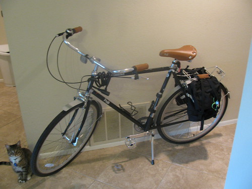
Bicycling.
Used for: Most trips within a 10 mile radius that I take alone, including moderate cargo hauling. My bike is my go-to transportation tool, and serves the majority of trips I take. You'd also be amazed at the amount of cargo I can haul on the back, with nothing more than panniers and a rear rack. (I'm drooling over the amazingly versatile Burley Travoy trailer, but haven't plunked down the money yet.) Sadly, my wife is difficult to coax on to the back of a bicycle, so it's rare that we pedal places together.
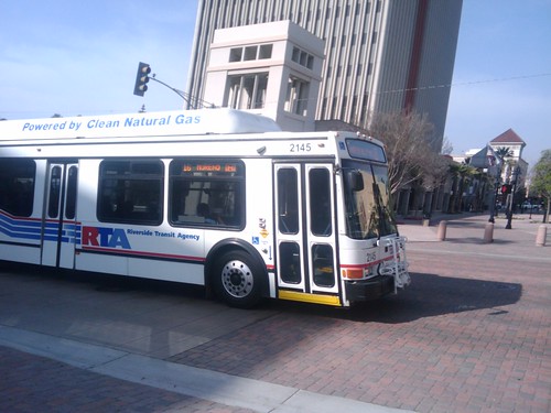
Local Bus.
Used for: A lot of around-town trips, especially during inclement weather, as well as some longer-distance trips that would be difficult to manage on a bicycle. I also used the RTA to haul food for 80 Occupiers downtown earlier, so it's occasionally useful for certain specialized types of cargo. I can also, occasionally, manage to get Dani on to a bus, so we've been known to go out together via transit.
Commuter Rail.
Used for: Pretty much every trip I make to LA or Orange County (though I sometimes use the bus to the OC). Also occasionally the first step in longer-distance rail trips, leaving from LA Union.
Scooter.
Used for: Most trips my wife makes, along with a lot of trips that the two of us makes. It will haul the both of us, and not a whole lot more, so it's not generally used for more than light shopping.
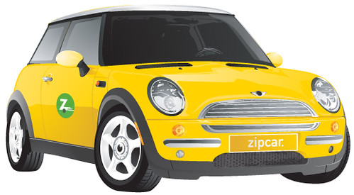
Zipcar.
Used for: Shopping trips, mostly. It's also a great backup when one of us has the scooter and the other one *has* to get somewhere quickly, or when we were dealing with car breakdowns.
Long-distance Rail.
Used for: Any long-distance trip that it makes sense for, including my 30-day 25-state 4-province Amtrak trip. Travel by train is my favourite way to travel- especially if I can afford sleeper.
Long-distance bus.
Used for: Trips where the train can't hack it. Sometimes, I use Greyhound as a supplement to Metrolink and other intra-regional services. Other times, it's used for long highway trips. One must be careful when trying to take the Hound to Vegas.
Aircraft.
Used for: Long-distance domestic trips where time is a factor, as well as international trips (which I haven't taken enough of...).
Once you get away from the car-centric paradigm of transportation, a whole range of transport options opens up to you- and it's important, for all of the reasons that readers of this blog already know, that we restore balance to our transportation system.
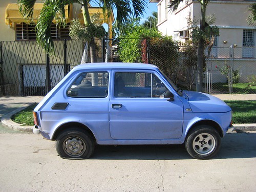
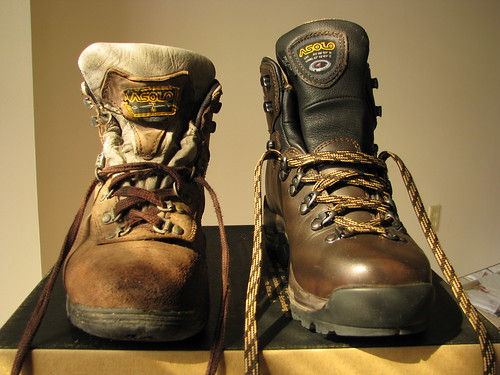
NOTE: The photos of the car, ZipCar, airplane, Greyhound bus, and hiking boots are not mine. They are used under Creative Commons licensing, and the photographers are credited in the alt text.
Auto Addict's Transportation Toolbox:
Automobile.
Used for: The vast majority of trips, from the corner store to the daily commute to the occasional cross-country road trip.
Aircraft.
Used for: Moving people for most long-distance trips, generally around a thousand km and up.
Not a lot of diversity here. Now, granted, a lot of people will engage in a walk from time to time, and there are quite a few recreational hikers and cyclists out there... but, for pure transportation, this is roughly what many Americans' lives look like, especially in suburbia- and especially for what used to be called "the middle class." The design of many tract developments especially almost necessitates a toolkit that looks like this, as it often walls people off from walking, cycling and taking transit. Furthermore, for long-distance transportation, many are entirely unaware of our national rail system and (despite encouraging changes in the northeast and in Chicagoland) disinclined to use long-distance bus service.
Let's now take a look at what my transportation toolkit looks like. Now, I'm not saying I'm perfect, but it should be clear that an awareness of one's transportation options allows a better matching between the job at hand and the tool used to do it.
Car-free Transportation Toolbox:
Walking.
Used for: A small number of very short trips, often with company. Honestly, I don't walk too much, but I do on occasion. As I've mentioned, we have a fairly nice shopping centre within five minutes' walk of our apartment, and so sometimes the wife and I will walk there for shopping or a nice dinner.
Bicycling.
Used for: Most trips within a 10 mile radius that I take alone, including moderate cargo hauling. My bike is my go-to transportation tool, and serves the majority of trips I take. You'd also be amazed at the amount of cargo I can haul on the back, with nothing more than panniers and a rear rack. (I'm drooling over the amazingly versatile Burley Travoy trailer, but haven't plunked down the money yet.) Sadly, my wife is difficult to coax on to the back of a bicycle, so it's rare that we pedal places together.
Local Bus.
Used for: A lot of around-town trips, especially during inclement weather, as well as some longer-distance trips that would be difficult to manage on a bicycle. I also used the RTA to haul food for 80 Occupiers downtown earlier, so it's occasionally useful for certain specialized types of cargo. I can also, occasionally, manage to get Dani on to a bus, so we've been known to go out together via transit.
Commuter Rail.
Used for: Pretty much every trip I make to LA or Orange County (though I sometimes use the bus to the OC). Also occasionally the first step in longer-distance rail trips, leaving from LA Union.
Scooter.
Used for: Most trips my wife makes, along with a lot of trips that the two of us makes. It will haul the both of us, and not a whole lot more, so it's not generally used for more than light shopping.
Zipcar.
Used for: Shopping trips, mostly. It's also a great backup when one of us has the scooter and the other one *has* to get somewhere quickly, or when we were dealing with car breakdowns.
Long-distance Rail.
Used for: Any long-distance trip that it makes sense for, including my 30-day 25-state 4-province Amtrak trip. Travel by train is my favourite way to travel- especially if I can afford sleeper.
Long-distance bus.
Used for: Trips where the train can't hack it. Sometimes, I use Greyhound as a supplement to Metrolink and other intra-regional services. Other times, it's used for long highway trips. One must be careful when trying to take the Hound to Vegas.
Aircraft.
Used for: Long-distance domestic trips where time is a factor, as well as international trips (which I haven't taken enough of...).
Once you get away from the car-centric paradigm of transportation, a whole range of transport options opens up to you- and it's important, for all of the reasons that readers of this blog already know, that we restore balance to our transportation system.
NOTE: The photos of the car, ZipCar, airplane, Greyhound bus, and hiking boots are not mine. They are used under Creative Commons licensing, and the photographers are credited in the alt text.
Wednesday, November 9, 2011
How do we think about multi-modal transportation?
The Atlantic has a great piece on Missouri's first-in-the-nation "diverging diamond" interchange, where a livable streets advocate (Charles Marohn) contrasts his interpretation of a walk through the interchange with that of the engineer promoting it. In a larger sense, though, Marohn asks us to think about how we integrate non-auto modes into our transportation system.
Marohn alleges in the video (around 7:00 or so) that the way that traffic engineers think about non-auto mobility is flawed. He says that the design is, first and foremost, designed to meet "the standard engineering parameter of being able to move cars very quickly through here," and only after meeting that criteria are any alternative modes considered. He concedes that the design accommodates pedestrians and cyclists better than some intersections, but that it still demonstrates an overwhelming preference for automobiles over other modes.
If we are really serious about shifting away from the dominance of the car, we need to think about designing transportation systems to accommodate all modes equally, rather than designing for cars first and leaving everyone else as an afterthought.
Thursday, November 3, 2011
Simple Truths
I'm in a ranty mood today, so here goes. What follows is a short list of simple truths about alternative transportation that are nevertheless ignored by many denizens of Riverside:
- The bus is not smelly or dirty, generally speaking, nor is it full to the brim with borderline psychotics.
- Bicycle lanes are intended for the use of bicycles. Not joggers, strollers, skateboards, or kick scooters, but bicycles.
- Sidewalks are intended for the use of pedestrians, skateboards, kick scooters, etc., but not bicycles.
- The back of the bus is going to the same place as the rest of the bus- which means it's a-okay to stand back there, rather than smoosh together so tightly that nobody can board.
- Board at the front door, exit at the rear.
- SUV-sized strollers don't fit well on buses, especially at rush hour.
- Metro does not serve Riverside.
- Bicycle lanes, just like nearly every other kind of lane, travel in one direction only. In fact, they're even painted with helpful little arrows to remind you of which direction that is.
Wednesday, October 26, 2011
A Declaration of Independence!
As of a few minutes ago, I am car-free. Dani and I sold our aging Honda Civic to somebody who could better take care of her. We have no plans to buy another car. How were we able to accomplish this monumental feat in the middle of car-centric suburbia?
Well, to be honest, dear reader, we cheated. My wife works as a substitute teacher, and it is impossible to reach around half of her school sites on time by transit- and she won't be bicycling to Redlands any time soon. (I'm working on it!) Therefore:
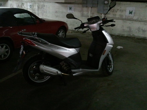
We're now the owners of a 2009 Aprilia Sportcity 250 scooter. Before you laugh, it gets 3.6l/100km (65 MPG) and will haul both of us at freeway speeds. So are we motor vehicle free? Not yet at least. But I have to think that going from 816kg (1800lbs) of vehicle to 158kg (350lb), and from ~9l/100km (25MPG) to 3.6l/100km (65MPG), is a significant improvement.
Without a car, our transportation toolkit has changed quite a bit- a subject which I'd like to cover in a later post. Just now, it's a time for celebration.
Well, to be honest, dear reader, we cheated. My wife works as a substitute teacher, and it is impossible to reach around half of her school sites on time by transit- and she won't be bicycling to Redlands any time soon. (I'm working on it!) Therefore:
We're now the owners of a 2009 Aprilia Sportcity 250 scooter. Before you laugh, it gets 3.6l/100km (65 MPG) and will haul both of us at freeway speeds. So are we motor vehicle free? Not yet at least. But I have to think that going from 816kg (1800lbs) of vehicle to 158kg (350lb), and from ~9l/100km (25MPG) to 3.6l/100km (65MPG), is a significant improvement.
Without a car, our transportation toolkit has changed quite a bit- a subject which I'd like to cover in a later post. Just now, it's a time for celebration.
The Downtown Parking Epidemic
In meeting after meeting, I have noted the same observation as this Fresno blogger: people think that there is a parking shortage downtown, and yet parking is so plentiful it is strangling decent urbanism there.
I assume this is because *free* parking downtown is relatively scarce, when compared to everywhere else in suburbia, and that parking is somewhat slightly further away from their destination than they are used to. This minor inconvenience imposed upon drivers is so alien from their usual day-to-day travels (if they don't visit downtown regularly) that it is unthinkable to them, and obviously the City should be doing something to remedy that inconvenience immediately.
Meanwhile, those of us who choose to use alternative forms of transportation put up with greater inconveniences regularly: long waits for buses, unsafe streets for bikes and pedestrians, a lack of bicycle parking, the list goes on. This is transportation inequity in action.
Sunday, October 23, 2011
Grids, Permeability, and Cycling
I mentioned in a few recent posts that grids are pretty much the ideal network design for any mode of transport, assuming high frequencies. (Low-frequency transit networks, from local bus to airline, can often work best in a hub-and-spoke design, but that's a post for another day.) I'd like to mention a related concept now: permeability. Permeability is a measure of how easily one can move through a city. If you can move easily through an area, without a lot of twists and turns, that area is permeable. Most importantly for those of us trying to create a better city, permeability can be different for different modes.
View Larger Map
Take a look at this slice of Riverside, for example. This is Central and Chicago Avenues, in Canyon Crest. If you are in a car heading down Central and you want to continue west towards Riverside Plaza, you need to turn south on Chicago, drive up the hill to Alessandro/Central/Arlington/Chicago*, and turn west again. If you're walking or on a bike, however, you can use one of my favourite bits of cycle infrastructure in the city- a class I bike path that snakes up into the hills, roughly continuing the line of Central Ave. to Fairview, which takes you through to Central on the other side. (You'll have to zoom in on the above map to see it.)
This particular bit of city is more permeable to cyclists and walkers than it is to drivers- and that's a good thing. It means its a bit easier for a cyclist to get around this neighbourhood than it is for a driver to do the same, which should lead more people to cycle or walk. This is also the central insight behind bicycle boulevards, which allow through cycling but block through motor vehicles.
Of course, facilities out here in the 'burbs can also be designed with improved permeability for motorists, at the expense of other modes. Coming back to Canyon Crest, the Towne Centre shopping centre provides an excellent pedestrian experience- once you're inside. On the outside, there are only three dedicated pedestrian entrances, compared to 7 car entrances- and all pedestrian entrances simply dump you out into the parking lot, often on the hood of a parked car. Even though the Towne Centre is in a relatively walkable area, it is significantly more permeable to auto (and, to some extent, bicycle) traffic than pedestrians.
Making our cities more permeable to pedestrian traffic is not terribly difficult, but it requires thinking about mobility in different ways. There is, for example, no reason for a development to wall itself off entirely from the arterial road it sits on. Adding pedestrian paths (or, for the paranoid, gates) at the end of culs-de-sac would allow residents to choose to walk, rather than being discouraged by a roundabout process for exiting their subdivision. Perhaps some roads could receive a bicycle boulevard-style treatment, becoming closed to through car traffic. (Best of all, those sorts of changes are often clamored for by folks looking to calm neighbourhood traffic.) Small- and cheap!- changes in road design could easily make active transportation the obvious choice for a huge proportion of trips, without disturbing the flow of arterial traffic.
Friday, October 21, 2011
More Delays?
Thanks to a group called Friends of the Riverside Hills, who filed a lawsuit challenging the EIR, the Perris Valley Line will be delayed yet again.
I think it's telling that the bulk of links that come up on Google for this organization are litigation-related.
I think it's telling that the bulk of links that come up on Google for this organization are litigation-related.
Thursday, October 20, 2011
Good news!
Long Beach bike consultant and livable streets hero Charlie Gandy may soon have a new home. It was reported at last night's Bicycle Advisory Committee that the City is finalizing a hiring deal with him, and will be taking him on for a short period as a bicycle consultant.
To quote Joe Biden, this is a big f**king deal.
To quote Joe Biden, this is a big f**king deal.
Monday, October 3, 2011
#OccupyRiverside!
Update: General Assemblies are held on Monday and Saturday at 7pm on the pedestrian mall, between University and 9th.
This isn't transit-related, but it is related to having a functional democracy in our society. I hope you're all aware of the #OccupyWallStreet movement by now, and those of you who are very clued-in will know that there are now occupations around the nation, including in downtown Los Angeles.
What I doubt most of you know, and what you really ought to know, is that there is a nascent OccupyRiverside organization. (They're also on Facebook.) The first General Assembly meeting will be held tonight at 7pm, at the Gandhi statue in downtown Riverside. The location is easily accessible by public transit, a short walk from either the Riverside Downtown Terminal (1, 10, 12, 13, 14, 15, 16, 22, 29, 49, 204, 208, 210, 212, 216, Omni 215, Greyhound) or the Riverside-Downtown Metrolink (Riverside Line, IE-OC Line, 91 Line, Amtrak San Joaquins, Amtrak Southwest Chief). The occupation hasn't begun yet, but meetings like this are critical to planning the eventual protest.
Now we return you to your regularly-scheduled bus blogging.
SoCal Rideshare Week- with a free Omni ride!
It seems Omni must have read my post about free trials*, because they're handing out an Internet coupon for a free day pass. Simply print it out (in colour!), cut it out and hand it to a bus driver any day during SoCal Rideshare Week, which happens to be this week, 3-7 October.
You'll have to answer a one-question survey to get the link to the coupon.
*They actually do this a lot, so I can't really take credit.
You'll have to answer a one-question survey to get the link to the coupon.
*They actually do this a lot, so I can't really take credit.
Tuesday, September 27, 2011
RTA is Hub-and-Spoke, and That's a Good Thing
I've heard this complaint before, including at least one occasion from a guy at a planning meeting who should have known better. It runs something like this- RTA is a terrible transit system because it's a hub-and-spoke design, and if we could just design a grid system it'd work out a lot better. I got a version of this in an e-mail from a reader (citing this Atlantic article on a recent Tallahassee re-design as a model for RTA), and after writing a lengthy reply, I figured I might as well turn that work into a blog post.
A decentralized grid system is the best of all possible designs for public transit, but it depends very heavily on having very high frequencies- say, 10-15 minutes at the outside, preferably closer to 5 minutes- on every route in the system. If you can't pull that off, it's better to design your system as a hub-and-spoke system, like RTA's, and to engineer timed transfer (or "pulse") points at each hub. (RTA does this, but they don't advertise it well.) That way, even though frequencies as a whole are abysmal, transfer wait times at system hubs are significantly less than they would be if buses just randomly met along their way.
The trouble with moving from a hub-and-spoke system to a more grid-like system in a relatively low-ridership system is that these timed transfer points become almost impossible to engineer. On the Tallahassee map (PDF), line M is a not-quite-downtown north-south route that crosses nearly all of the east-west routes at different points. It would be nearly impossible to schedule the M so that it connects well with the E at the end of its run, the A and C outside of downtown, the F, the T, the D, the L and B, and the G all at different points. When you then consider that each of those routes would need to be scheduled based on a similar number of transfer points, you might get a very fragile and illegible schedule that is operationally very difficult to maintain (eg. one bus is late, breaking the whole system), or (more likely) you get very little concern for the wait time of people transferring, so that the average wait time for the next bus is awful. (Average wait is 1/2 * frequency, which ranges from 20-50 minutes in Tallahassee, and from 20 to 120 minutes on RTA.) In a well-designed "pulse" system, transfer wait times can be reduced to mere minutes at the hubs.
We actually have a local example of a low-frequency grid system: OCTA. Back in the 80's, OCTA went from a hub-and-spoke system to a grid system, with decent frequencies and promises for improvement. However, the grid-supporting frequencies never materialized, and riders are now stuck with interminable transfer waits at unpleasant arterial intersections.
Part of the reason I think I keep seeing this idea reoccur is that grid systems work well for nearly every other sort of network. It goes without saying that cars love grids, but just last month I was also extolling their virtues for cyclists. This is an example of what Jarret Walker talks about in the recently-posted introduction to his book:
For example, in most debates about proposed rapid transit lines, the speed of the proposed service gets more political attention than how frequently it runs, even though frequency, which determines waiting time, often matters more than vehicle speed in determining the total time a transit trip will require. Your commuter train system will advertise that it can whisk you into the city in thirty-nine minutes, but if the train comes only once every two hours and you’ve just missed one, your travel time will be two hours and thirty-nine minutes, so it may be faster to drive or even walk.
I can explain the concept of frequency to a motorist, and she may even understand, intellectually, why it’s important. But what she knows is the experience of driving, where speed matters and frequency doesn’t. So when she makes a decision about a transit project, she is likely to give frequency too little weight. The result can be services that are very fast but don’t come when we need them, or that require too much time to connect from one service to another.Similarly, hub-and-spoke designs for transit pretty much only make sense for transit, because transit travel time is linked inextricably to service frequency. When you draw lines on a map, it looks terribly inefficient- but you have to realize that, at least outside of big-city transit networks, lines on a map are a very small part of the reality of transit service on the ground.
Friday, September 23, 2011
BAC Meeting
The next meeting of the Bicycle Advisory Committee will take place on October 19th, 2011. More details as I get them.
Wednesday, September 21, 2011
Omni gets on the U-Pass bus
Omni's new Go Smart! program, similar to RTA's U-Pass program, allows students from most public colleges and universities in the service area to ride free during the school year. Crafton Hills, San Bernardino Valley and Chaffey Community College students, as well as students at Cal State San Bernardino, can ride free on any Omntirans bus simply by swiping their student ID cards. This program is in a trial phase this year, so if you're a student at any of thee above colleges you should ride as much as possible in order to show your support.
Sadly, the program only works during the school year. RTA's program is year-round, allowing those of us who don't go "home" for the summer to continue to enjoy public transit. (My home is the one I've made here, not the house I grew up in, no matter how many students may disagree with me.) Hopefully, if the program is a success, it will be expanded to year-round.
Interestingly, unlike RTA's program- which is funded by the colleges and universities themselves (and, in the case of RCC, by a direct fee levy on the students)- Omni's program is funded by the city governments who lie within the service area. In a time of increasingly scarce educational budgets, could this be an improved model for getting students to class?
Friday, September 16, 2011
Free Trials
I was spurred in to thinking about this by a recent presentation at Greater Riverside Transportation Now! An RTA representative, Virginia Werly, was on hand to talk about a new travel training program put on by the agency under a new grant agreement with RCTC and the FTA. The agency will send out a bus and some staff to senior centres around the service area in order to get people familiar with how to plan trips on the fixed-route transit system, and then will provide them a free 30-day pass in order to encourage them to put these skills in to practise as well as to asses how well they are doing so. The thinking behind the program is that it would reduce the cost of providing Dial-A-Ride service to the local senior population by shifting their travel onto cheaper fixed-route transit. (One of the things I learned at the meeting is just how frakkin' expensive Dial-A-Ride service is, but I'll cover that some other time.)
At the meeting, however, I brought up the idea of expanding this sort of travel training program to the general public, or at least to specific populations such as college and university students. Obviously, the agency cost argument wouldn't be there, as the transportation alternative for pretty much anyone who's not elderly or disabled is the private car, but it would be a tool that could help increase ridership and reduce automobile dependency. According to The Atlantic, some researchers in Sweden had a similar idea. Turns out that drivers expect to dislike transit before they use it, but once they do, they rate the experience much higher than they originally expected- and their ratings increased with time. I've said similar things in the past- people perceive the typical city bus as a dirty, dangerous place full of freaks and weirdos, but the reality of riding the bus is markedly different.
The key here, I think, lies in the free transit passes. Each of the people in the study was interested in changing their transportation behaviour, and was given a way to do so- a 30-day transit pass. Accordingly, their transition to transit was made a bit less costly. Couple that with even a mild form of travel training- perhaps a brochure explaining the use of Google Transit and 511- and most people would probably find discovering transit simple. And, once they've discovered transit, they're probably likely to stick with it- I know of at least four people in my personal life who I've convinced to switch to transit, and they're all still sticking with it. (It didn't take much more convincing beyond "I'm sorry to hear about your commute. Have you considered taking the bus/train? It's easy, and there's a route that serves your needs.") Best of all, it would cost essentially nothing. The great strength of transit lies in the fact that the marginal cost of each new rider is essentially zero. If a rider uses the pass a lot and becomes a transit convert, great! Ridership! If they don't, all you've spent on them is the cost of the pass stock and glossy brochure.
Tuesday, September 13, 2011
Campus Mobility Stunted
At the end of the Spring quarter of this year, UCR Parking and Transportation Services announced (very, very quietly- I didn't notice) that they were permanently ending ALL campus shuttle service. This makes UCR the only general UC campus without any University-operated shuttle service. Furthermore, their justification for doing so requires some scrutiny.
According to the announcement, the Highlander Hauler shuttle services "did not receive money from the state, the university or student fees." The department made the decision to close down the shuttles due to "the unprecedented impact of the campus budget crisis." But wait... the shuttles were funded entirely by parking fees and fines. Parking fees have gone up, as has enrollment (so I doubt fewer students are parking), and it's unlikely that people have stopped parking illegally in large numbers. The campus budget crisis has been caused by a reduction of state support to the campus- the very pot of money that the department itself acknowledges is not used to fund the shuttle service. This means that the parking fee and fine money that used to fund the shuttle is being re-directed to fund something else entirely.
Of course, I have a theory as to what that might be. At one of the many community meetings I attend, a UCR official noted that the UC does not provide a budget to each campus for parking. Each campus must build and maintain their parking lots out of student fees. The official was lamenting the fact that UCR is running out of land to build surface parking lots on, requiring more expensive parking structures to be built. Even while Parking Services has even more money coming in from raised parking fees, they don't have enough money to pay for the parking structures they think will be required to meet student demand in the future- and so they chose to cancel the shuttle program in order to re-direct that fee money to parking lots.
Obviously, this is counter-productive. Granted, the campus shuttle system did not serve huge distances, with the most popular route running from the dormitories to the University Village. In an ideal world, the trips that this service served would be accomplished by walking, cycling, or the brief use of the RTA 1 or 16. This is not an ideal world, however- this is Riverside. A great number of students already drive from the main campus to the University Village. Some will, of course, switch to one of the modes outlined above- but some will undoubtedly find themselves "needing" to bring a car in order to reach the University Village lectures, causing an even worse impact on campus parking and traffic and- it goes without saying- further environmental degradation.
As a community service, I will be posting up flyers at the old Highlander Hauler stops pointing folks towards their newly-reduced transportation options. I also condemn this action by the University as an example of movement in precisely the wrong direction. Shame on you, TAPS.
Thursday, September 8, 2011
"Commuters" and the Jefferson Ave. Bike Lane
At last night's Parking, Traffic and Streets Commission meeting, we approved parking restrictions for most of Jefferson Avenue in order to facilitate the installation of bike lanes from Victoria to Arlington. The usual arguments about people's sacrosanct right to park their private cars on the public property immediately in front of their homes were in full bloom, and at least one member of the public argued that the bike lanes would "lower [their] property values." (Never mind evidence to the contrary.)
The disheartening portion of the evening, though, was that the parking restrictions in the bike lanes were only proposed on weekdays from 7am-6pm, and there was no support in the room save myself for extending them further. Why these times? Because, in the words of City Traffic Engineer Steve Libring, it was thought that these times would accommodate school and commuter traffic.
Yup! "Commuters" will make my Jefferson Ave. bike lane vanish.
On the whole, the Jefferson lanes are a great addition to the City's bike network, especially considering they will be the first bike lanes to cross the 91 freeway north of La Sierra. Still, I wish we didn't have to make the lanes less effective in order to provide still more space for private cars.
Sunday, September 4, 2011
Reminder- No Labour Day Bus Service!
Best of luck getting to those barbecues, folks. There will be no bus service on Labour Day- which is tomorrow, Monday the 5th. Both RTA and Omni are shut down. Riverside Special Transportation (for seniors and the disabled) is also not running. Metrolink is only operating the Antelope Valley Line, on a special holiday schedule. OCTA and Metro will run on holiday schedules, while Foothill will run on a weekend schedule.
If you need to get around Riverside, the bike lanes will be open. You can also pick up a ZipCar at UCR, if you can snag a reservation. Riverside's three cab companies are available at:
For inter-city transportation, Greyhound serves San Bernardino, Claremont, Santa Ana, Anaheim and LA. Amtrak also has one train daily to LA, leaving at 5:53am from the Riverside-Downtown station (south platform, over the bridge) and returning at 8:03pm.
Good luck!
If you need to get around Riverside, the bike lanes will be open. You can also pick up a ZipCar at UCR, if you can snag a reservation. Riverside's three cab companies are available at:
| Company | Tel. |
|---|---|
| AAA Inland Empire Cab | 1-888-333-TAXI (8294) |
| Yellow Cab Riverside | 951-286-6666 |
| Happy Taxi | 951-781-TAXI (8294) |
For inter-city transportation, Greyhound serves San Bernardino, Claremont, Santa Ana, Anaheim and LA. Amtrak also has one train daily to LA, leaving at 5:53am from the Riverside-Downtown station (south platform, over the bridge) and returning at 8:03pm.
Good luck!
"Commuters" are killing us
No, I don't mean the actual people who commute. Rather, I'm talking about how any transportation conversation seems to frame those seeking transportation as "commuters." Work trips are important, certainly, but they are not the most common type of trip taken on our transportation system. Daily work/school commute trips account for only around 20-30% of daily trips, and the most congested hour of the week on surface streets is actually 1pm on Saturday. To think only about the commute trip profoundly damages our transit system, as I've mentioned before, but it also impairs the way we think about other transportation topics.
Take, for example, bicycling. I wrote last week about the Bicycle Advisory Committee's slant towards recreational, rather than transportation, cyclists. Many of the other committee members also proudly state that they are "commuters," but note that wayfinding is (in their minds) less important for commuter cyclists. The committee chair told me that
First, note the auto-centrism. Many cyclists in this city, especially transportation cyclists, ride bikes because they can't drive, can't afford a car, or choose not to use an automobile for other reasons. Second, and more importantly for this post, is the assumption that a cyclist riding for transportation would be riding the same route, between home and work, over and over and over without deviation. This sort of view makes no provision for cycling to other destinations, such as the grocery store, social activities, or government meetings like those of the BAC. Thus there is a fundamental difference between panning infrastructure for bicycle commuters, and planning infrastructure for transportation cyclists- the latter being those who bike, not just to work, but to everywhere. Furthermore, our city will not be bicycle-friendly unless and until her residents can safely make, not only their work trip, but all of their day-to-day trips on a bicycle.
I once again encourage everyone to be very careful in their use of the word "commuter." It implies a very particular sort of travel, with often devastating impacts on alternative transportation.
*I wasn't taking notes when he said this, so this quote may not be verbatim. It captures the spirit of his comments.
Take, for example, bicycling. I wrote last week about the Bicycle Advisory Committee's slant towards recreational, rather than transportation, cyclists. Many of the other committee members also proudly state that they are "commuters," but note that wayfinding is (in their minds) less important for commuter cyclists. The committee chair told me that
If you're a commuter, you can plan out your route, look at the maps beforehand, learn the streets, maybe even drive it a few times before you commit to it.*
First, note the auto-centrism. Many cyclists in this city, especially transportation cyclists, ride bikes because they can't drive, can't afford a car, or choose not to use an automobile for other reasons. Second, and more importantly for this post, is the assumption that a cyclist riding for transportation would be riding the same route, between home and work, over and over and over without deviation. This sort of view makes no provision for cycling to other destinations, such as the grocery store, social activities, or government meetings like those of the BAC. Thus there is a fundamental difference between panning infrastructure for bicycle commuters, and planning infrastructure for transportation cyclists- the latter being those who bike, not just to work, but to everywhere. Furthermore, our city will not be bicycle-friendly unless and until her residents can safely make, not only their work trip, but all of their day-to-day trips on a bicycle.
I once again encourage everyone to be very careful in their use of the word "commuter." It implies a very particular sort of travel, with often devastating impacts on alternative transportation.
*I wasn't taking notes when he said this, so this quote may not be verbatim. It captures the spirit of his comments.
Sunday, August 28, 2011
Park[ing] Day is Coming- Call for Volunteers!
Okay all, Park[ing] Day LA is coming. It's on Friday, 16 September. Last year I went down to LA and had a blast touring the fantastic, creative pocket parks put up by Angelenos in metered parking spaces around their city. (There were also Park[ing] spaces in Santa Monica, Santa Ana and Laguna Beach.) This year, I'd like to bring that message and that creativity home to the IE.
I want to reclaim a parking space in downtown Riverside, somewhere close to the pedestrian mall, on 16 September. I can't do it alone- I will need creative, energetic folks with some free time on a Friday to help. I will also need:
So come on, readers, and help take back our city from the car, if only for a day!
I want to reclaim a parking space in downtown Riverside, somewhere close to the pedestrian mall, on 16 September. I can't do it alone- I will need creative, energetic folks with some free time on a Friday to help. I will also need:
- A painter's drop cloth, large enough to cover the parking space. Other alternatives, such as rugs, carpet remnants, or real or fake grass could also work.
- Cones or some other method of marking out the space.
- Chairs and tables- the better-looking, the better.
- Successful Park[ing] spaces often serve food to passers-by. A grill or ideas for a meal to serve would be welcome- especially if anyone has the recipe for the fantastic macaroni salad dish served at yesterday's Really Really Free Market.
- An EZ-Up, beach umbrella or similar shelter. I'm looking to snag a particularly nice, shady spot in front of the Blood Orange Infoshop/People's Gallery on University. If that doesn't happen, other protection from Riverside's legendary heat will be required.
- Creative, enthusiastic folks willing to help plan and man a Park[ing] space!
So come on, readers, and help take back our city from the car, if only for a day!
Friday, August 26, 2011
Bike Route Network
At this month's Bicycle Advisory Committee meeting last night, I got in a bit of a heated discussion with some of the other members. Many members of the committee are, as far as I can tell, primarily interested with improving the quality of recreational cycling within the city. That's all well and good, and I of course understand the joy of a good bike ride, but (as my readers know) I'm much more interested in using bicycles as a tool for sustainable transportation- to get people out of their cars and into a healthier, greener lifestyle. I've talked about this divide before, but it was very much on display last night.
The Committee proposed setting up a system of bike routes that could be compiled into a map book, signed and promoted by the City, and possibly be given priority in maintenance. A good thing, certainly, except for one detail- most Committee members saw these routes as loops or "rides" that people could follow in order to spend a day out on their bikes. Loop rides are great if you want to enjoy a bit of fresh air and exercise, but ultimately rather problematic if you want to do that on the way to somewhere of consequence.
I argued that what the City needed was a grid system of bike routes. Such a system, with lines stretching across the City, would be easy to understand, easy to follow, and could then serve as the basis of a way-finding system for more complex routes. Despite assurances that my ideas were good and valid, I think I was nearly alone in this opinion. However, the Committee Chairman asked to see the sort of grid network that I would propose, so here it is:
View Riverside Bikeways Network (proposed) in a larger map
The network is inspired in part by the Backbone Bikeway Network that the LA Bicycle Working Group came up with, and that was eventually largely adopted in LA's Bike Plan. Numbering was inspired by San Francisco, but Long Beach also has a similar system.
The driving idea behind the map is to link neighbourhoods across the City, primarily by using existing bicycle infrastructure. Every route except for #6 substantially follows existing or soon-to-be-built (Route 8) facilities. Nearly everyone in Riverside is within a mile of a numbered bike route, and in most cases could access one via low-traffic, neighbourhood streets. (The biggest exception to this is much of Woodcrest and Washington St., which lack bike facilities at present.)
While the lines look complicated, and in some cases have strange jogs in one direction or another (Route 7 at California, or route 2 at Kansas)- but ideally each of these routes would be signed on the street. Rather than having to memorise the safest route through an area, cyclists could simply follow the signs for their route. The network would not obviate the need for more local, neighbourhood bike facilities, but it would answer questions like "How do I get to downtown from Tyler Mall safely?" (Answer: ride up Magnolia, catch Route 10 at Van Buren to Route 1, and take that to Route 2.) It would also, as I mentioned before, create a framework upon which to build more complex loop rides. Want a quick family ride near UCR? Try the triangle created by routes 2, 5 and 7, all on at least Class II bike lanes. How about a ~15 mile ride on the south side of the city? Take 3 to 12 to 5 to 8. Want to do the ride that the BAC chairman mapped out as an example? I'm extrapolating from memory, but I'm pretty sure it'd be something like 7-5-3-12-1-2. Rather than having to try and guess which streets are safe and go from there, cyclists new to the area would have simple cues to direct them to safe, simple bike routes between any two points in the city.
So... what do you all think?
Friday, August 19, 2011
Service Expansion in Omni-Land
Omni's September Bus Book is nearly out, and with it comes a few changes. I want to call your attention to two of them.
First, the new "Interim Transfer Centre" in downtown San Bernardino. San Bernardino's "downtown transit mall" has long been the target of my ire. Rather than having a single, coordinated location at which bus transfers took place, riders (including myself) would often have to walk two or three blocks to find the appropriate bus shelter. I have seen transit malls done well, in Long Beach and in Portland, but never in San Bernardino. It's therefore a welcome surprise that, rather than waiting until the opening of the new E Street Transit Centre some years away, Omni has decided to consolidate all of their bus operations now, at an interim location on 4th between F and G.
Second, Omni has one small, yet important, service extension. In Chino, the OmniGo #365 will forge a brand-new inter-county connection between Foothill Transit and Omnitrans. Rather than having to either walk/bike a ways or take the 365 and 65 all the way to Montclair, riders can transfer to the Foothill #291 and #497 on one end of the OmniGo #365. Not only should this be a boon to local riders, putting them within one peak-hour transfer of Los Angeles, but it should also provide a good "anchor" on the far end of the line, ensuring steady ridership for the fledgling OmniGo service. Bravo, Omni!
So when do we get to start adding service?
Thursday, August 18, 2011
Irony Express: Now Arriving
Mere months after the City of Riverside got done double-super-banning food trucks, which were already banned by county health regulations, I opened up the City's "15 Favorite Things to Do" e-newsletter and find this:
Riverside Food Truck Festival
Downtown Riverside
(Food trucks are allowed, by permit, at specially-designated events.)
So huzzah! Riverside has decided to set aside one day of the year to celebrate the culinary diversity and entrepreneurship of food trucks! Of course, on the other 364, they could be shut down for peddling their tasty wares anywhere within the city limits.
Riverside and San Bernardino Counties are the only two counties in the state with a ban on hot food trucks. San Bernardino County just recently decided to loosen their regulations- and, although they don't go far enough, it's a step in the right direction. Riverside decides to do what seems to be Riverside's answer to everything- hold a festival! Perhaps this will lead to the public putting political pressure on their elected officials to bring food trucks here during the rest of the year, but it's at least good for a laugh.
Anyway, as my readers might (along with myself) enjoy the opportunity to sample the SoCal food truck renaissance's finest right here in River City, I should probably let you all know where this is happening. It'll be in downtown, at Market/3rd (in the mostly-empty Lot 33 near the Convention Centre.) Transit: RTA 12, 16, 29, short walk from Downtown Terminal (1, 10, 12, 13, 14, 15, 16, 22, 29, 49, Omni 215, 216). Tickets are $8 presale, $10 at the gate, $25 for a limited number of air-conditioned VIP tix.
Riverside Food Truck Festival
Downtown Riverside
The City of Riverside gets a taste of the food truck craze with the First Annual Riverside Food Truck Festival on Saturday, September 3. This event will feature 50 food trucks from throughout Southern California. Experience the trendiest gourmet, specialty and fusion foods. Find out for yourself why food trucks have moved from “roach coach” to Food Network and international fame. There’ll be live music, roller derby girls, sports celebrities, a family sport zone, games for all ages and a special VIP access area (almost sold out!). All proceeds will help support three non-profit organizations in Riverside: Asian Pacific Lunar Festival, Riverside Arts Council and Riverside County Prevent Child Abuse. Brought to you by Paul Davis, Ward 4 Riverside City Councilman.
(Food trucks are allowed, by permit, at specially-designated events.)
So huzzah! Riverside has decided to set aside one day of the year to celebrate the culinary diversity and entrepreneurship of food trucks! Of course, on the other 364, they could be shut down for peddling their tasty wares anywhere within the city limits.
Riverside and San Bernardino Counties are the only two counties in the state with a ban on hot food trucks. San Bernardino County just recently decided to loosen their regulations- and, although they don't go far enough, it's a step in the right direction. Riverside decides to do what seems to be Riverside's answer to everything- hold a festival! Perhaps this will lead to the public putting political pressure on their elected officials to bring food trucks here during the rest of the year, but it's at least good for a laugh.
Anyway, as my readers might (along with myself) enjoy the opportunity to sample the SoCal food truck renaissance's finest right here in River City, I should probably let you all know where this is happening. It'll be in downtown, at Market/3rd (in the mostly-empty Lot 33 near the Convention Centre.) Transit: RTA 12, 16, 29, short walk from Downtown Terminal (1, 10, 12, 13, 14, 15, 16, 22, 29, 49, Omni 215, 216). Tickets are $8 presale, $10 at the gate, $25 for a limited number of air-conditioned VIP tix.
Wednesday, August 10, 2011
Bicycle Advisory Meeting
The City of Riverside Bicycle Advisory Committee will meet on 25 August at 5:30, in the Mayor's Ceremonial Room at City Hall.
Art for Transit Geeks
Via Curbed LA, a new art installation is going in at LACMA:
Not only is this sculpture every little kid's dream- seriously, thousands of matchbox cars and several toy trains thrown in for good measure- but the artist notes that he's trying to make a statement about the coming end of the car-centered city. The crowded lift ramps evoke traffic-snarled freeways, and the noise (judging from the video) echoes the aggravating din of car-choked city centres.
LACMA is transit-accessible! Take the Metrolink in to LA Union Station, followed by the Purple Line to Wilshire/Western and the 720 to Wilshire & Fairfax. Admission is $15, $10 students and seniors, free on second Tuesdays. This might be a great outing for Metrolink's new Weekend Pass, just $10 for the whole weekend including local transit transfers.
Friday, August 5, 2011
The Rail-Bus Divide
I have written before on this blog about a problem faced by transit activists in promoting bus transit. Travel by bus is highly stigmatized, at least in the United States, and even people who are environmentally conscious may not be persuaded to ride a bus. (I'm looking here, of course, at my fellow middle-class white liberals.) This stigma is a cultural one, but it is also perpetuated by policy decisions in many places where buses and rail connect with one another. In order to have an effective public transit system, we need to allow people to travel easily regardless of mode. Some places do this better than others, and some do it much worse.
Of the places where I've been, the west coast cities of San Francisco, Portland and Vancouver probably do the most to minimize the bus-rail divide. San Francisco's Muni runs both light rail and bus services, and the two are treated equivalently as far as fare policy is concerned. In many cases, the decision to run a bus rather than a train on a given route seems to be determined by the city's famous hills, rather than ridership demand, and bus frequencies compete with- and often overtake- rail frequencies. Bus and rail are shown as similar-weighted lines on the same system map, as if either is an equally valid choice for travel. Downtown, Portland does much the same thing. Buses and light rail run along the same transit mall, are shown on the same map, and accept the same tickets. Outside of downtown, TriMet's system more resembles Vancouver's TransLink, where rail is used as a long-distance trunk line, connecting to buses at each station. The connections are always well-signed, with clear explanations of where each bus goes.
Roughly in the middle of this scale are Chicago and New York. Each runs an extensive rail system, and an even more extensive system of bus lines. If you're downtown in either city, you can't help but see at least a transit bus or two, and Chicago's El is prominent anywhere you look in the Loop. Fares on bus and rail are the same, and passes cover travel on both. However, if you are at a rail station, the only lines you will see on a system map are the rail lines. New York's famous Map shows only bus connections to the two airports. Even New York bus riders would be hard-pressed to find one of the elusive borough system maps, which show both rail and bus service. (When I was in New York this summer, I spotted one on a bus- but it was a Staten Island map. We were in Brooklyn. I have heard they are available at local libraries, if you ask.) Chicago has a bus/rail system map, which is impressive indeed, but it is posted only at bus stops- in effect saying that you needn't know about bus lines until you've already indicated your willingness to ride a bus. (Chicago's bus numbering scheme leaves something to be desired as well- 151 is a frequent line along Michigan Ave., while 17 runs a handful of trips on the edge of CTA's service area.) Both New York and Chicago, however, are well-integrated when compared with our nations' capital.
Washington, D.C.'s major transit operator is WMATA, also known as Metro. Like many big cities, Metro operates both an extensive bus network and a rail system. However, the agency seems to do its best to ensure that these two systems are not integrated. As a tourist in DC, every pamphlet seems to have Metro Rail stations or maps listed. Metro offers a day pass for tourist travel, allowing unlimited use until the end of the service day for a flat $9. There's also a weekly pass, a "short trip" weekly pass (which covers only a certain distance during rush hour) and a regional smart card. However, there is no pass that you can buy which will cover a combined trip by rail and bus. (Critics may say that this is because Metrorail uses a distance-based fare system, but the other major distance-based rail system, San Francisco's BART, offers monthly flash passes for connecting operators and discounted transfers to local bus and rail systems. Our own Metrolink offers distance-based passes which include bus service.) Furthermore, there are no bus maps in the stations, and bus maps at the stops include only schematics of the route they serve. Even the D.C. Circulator, which seems to be an attempt to specifically alleviate the stigma of city buses, is not well-mapped nor integrated with Metrorail fares.
Most of the time during our vacation, Dani and I rode rail lines. They tend to be better-advertised, more predictable, and more frequent (as a class) than bus lines, and so they are often the default choice of somebody who doesn't know the system well. In every other city, however, we used buses at least a few times- while the networks were not as integrated or as legible as they should be, they were integrated and legible enough to be useful to even brief visitors such as ourselves. In D.C., however, we didn't ride even a single solitary bus. There were times when I very much wanted to, even- because of the layout of Metrorail in downtown D.C., a trip that should have been 5 minutes on a bus was nearly 30 on three different trains. However, the fact that I had paid for the rail day pass and didn't have change for the bus kept me underground, wasting my time. Policies like this, which actively segregate "rail riders" from "bus riders," make a transit system unnecessarily complicated and fail to leverage existing transit infrastructure. D.C. Metrorail has a severe crowding problem during the morning rush- how much of it could be solved by letting riders choose the bus instead?
By the way, a commenter earlier mentioned to me an interesting development in the field of bus-rail integration right here in SoCal. Along with six new intra-county OC Line trains (which, I believe, represent the first non-IEOC Line trains not to stop at LA Union Station), OCTA is now promoting the "OC Link" pass. For only $7 on weekdays, riders get a day of access to any OCTA local bus and any Metrolink train within Orange County. This is a commendable venture, allowing riders a quick, inexpensive way of making intermodal journeys and using spare capacity on LA-bound Metrolink trains. I'm still disappointed in RTA's one-transfer-only Metrolink policy, and they're certainly a long way away from something like this. (I should mention that I proposed a similar agreement for RTA some time ago.)
Thursday, August 4, 2011
"They want to tax the Internet"
Those words were spoken by a signature-gatherer at the Riverside Downtown Terminal last week, trying to get me to sign on to an effort to repeal the recently-passed AB28. AB28 would require out-of-state Internet retailers to collect California sales tax and pass it along to the state. The signature-gathering effort, which is almost certain to succeed, has been funded primarily by Amazon.com.
Now, like anyone else, I don't like paying taxes. If I were able, I'd simply avoid paying them, and revel in the enjoyment of an instant 10-30% boost in my income. However, I understand what it is that taxes pay for. The school I attend, the clean water I drink, the parks I enjoy, the (relatively) clean air I breath, and of course the bike lanes that I ride along and the buses and trains that I ride, are all funded by tax revenue. In California in particular, we rely heavily on sales taxes to fund our government expenditures, and those tax revenues have been dwindling due to the recession and continued unemployment crisis. (Surprise surprise, but when people lose their jobs they tend to buy less stuff.)
I also tremendously enjoy shopping online, and do a lot of it at Amazon. They tend to have cheaper prices than comparable brick-and-mortar stores (though not always- Fry's has been known to beat their online competitors), and Prime membership gives me both streaming video and free shipping. However, I don't shop online because I'm trying to avoid sales taxes. I'm sure some people do, but by and large most folks I know shop online for the same reasons I do- better selection, better prices, and the convenience of shopping from home and getting stuff delivered. (By the way, I'd bet that shopping online is probably greener too, with one UPS truck performing the job of several private cars.)
The long and short of it is that this anti-sales-tax campaign by Amazon is unnecessary- it probably won't hurt Amazon's sales all that much- and will inevitably hurt the already-deteriorating quality of California's state services. Furthermore, I think the framing being pushed by signature-gatherers-- "they want to tax the Internet"-- is misleading at best. This is not a tax on Internet access or use, but a collection of sales tax that (technically) you're obligated to pay anyway. (Look at the "Use Tax" section of your California form 540. Yeah, all those Amazon goodies really should be on there.) If you care about the quality of our public services, including public transit and street improvements, don't sign any petition repealing an Internet sales tax-- and vote it down when it (inevitably) comes up for a vote this fall.
EDIT: This was Riding in Riverside's 500th post!
Thursday, July 28, 2011
sbX Contracts Approved
Sneaky San Bernardino... while I was away, they approved the construction contracts for the new sbX bus rapid transit project. According to the PE, construction is slated to begin this year. Congratulations to Omnitrans for starting work on the inland area's first rapid transit project!
Oh, yeah. The contract bid was also nearly 20% below budget.
Oh, yeah. The contract bid was also nearly 20% below budget.
Wednesday, July 27, 2011
The Gearheads are Coming Around
Car and Driver, one of the oldest and most-respected automobile magazines in the country, is on our side:
Remember- public transit makes life better for everyone. Nobody likes being stuck in traffic. Everyone wants a little more time in their day. Everyone wants cleaner air, better water, and stronger communities-- even people who love their cars. Along with Wired, I previously argued that recreational driving is not the problem, and that even auto addicts ought to be able to reap the benefits of a more diverse transportation system. It seems that the auto addicts agree with me.
It is an axiom of traffic planners that increased speed due to capacity building is temporary; as traffic flows more smoothly, word gets out, and that attracts more traffic, eventually causing the same traffic-flow issues as before. The inevitable conclusion is that we cannot possibly build enough roads to satisfy demand, so we must consider alternative transportation systems.
This country has not had a comprehensive transportation strategy in decades, but now is an excellent time to consider one. And that means we need to take a hard look at what role highways should play and how they fit into the broader transportation network. Sprawling car-centric cities like Los Angeles, Phoenix, Salt Lake City, and Dallas are rushing to build new mass-transit systems—they have to; the roads they have cannot satisfy demand. So they must harmonize with other modes of transportation to reduce the stress on existing roadways as much as possible.
Remember- public transit makes life better for everyone. Nobody likes being stuck in traffic. Everyone wants a little more time in their day. Everyone wants cleaner air, better water, and stronger communities-- even people who love their cars. Along with Wired, I previously argued that recreational driving is not the problem, and that even auto addicts ought to be able to reap the benefits of a more diverse transportation system. It seems that the auto addicts agree with me.
Tuesday, July 26, 2011
PV Line Approved!
Inland News Today reports that RCTC approved the final environmental impact report for the Perris Valley Line Metrolink extension. They expect federal approval "within weeks" and construction starting by the end of the year.
Of course, the PVL will do very little to shift mobility patterns out here in Riverside County. Commuter rail is really a tool to reduce inner-city traffic, and to provide for a smoother commute for suburb-CBD trips. Still, more transit is more transit, and I will look forward to riding the rails to the Orange Empire Railway Museum- the Perris depot has been designed to provide a cross-platform transfer to their excursion trains.
Of course, the PVL will do very little to shift mobility patterns out here in Riverside County. Commuter rail is really a tool to reduce inner-city traffic, and to provide for a smoother commute for suburb-CBD trips. Still, more transit is more transit, and I will look forward to riding the rails to the Orange Empire Railway Museum- the Perris depot has been designed to provide a cross-platform transfer to their excursion trains.
Monday, June 20, 2011
Blog-cation
As you read this, my wife and I are on our way to Los Angeles Union Station for the start of what we're calling Epic Train Trip. We're touring the United States and Canada for the next month via Amtrak, with a smattering of Greyhounds and ferries in between. Accordingly, this blog will be a bit quieter. I do plan on posting interesting observations about transit in the cities we travel to, but I won't commit to a regular posting schedule.
Don't despair, however! Although I'll cut back on the blogging here, the wife and I will be chronicling our adventures on our travel blog, Backpack Amtrak. If you're interested, you can enjoy our adventures around the country on a train (and a shoestring budget) over there.
Don't despair, however! Although I'll cut back on the blogging here, the wife and I will be chronicling our adventures on our travel blog, Backpack Amtrak. If you're interested, you can enjoy our adventures around the country on a train (and a shoestring budget) over there.
Sunday, June 19, 2011
This Week in Transit
As usual, local events in red, HSRA events in orange.
If you find this feature useful, please don't hesitate to subscribe to either of these calendars. Also, don't forget to follow my IE transportation Twitter list, @plattypus1/ie-transportation.
If you find this feature useful, please don't hesitate to subscribe to either of these calendars. Also, don't forget to follow my IE transportation Twitter list, @plattypus1/ie-transportation.
Saturday, June 18, 2011
New Metrolink Fares
As I covered earlier, new Metrolink fares are coming. The new 7-day and weekend passes will become available on July 1st. The Family & Friends 4-Pack will be discontinued on the same day, while the 10 Trip tickets will be phased out by this fall.
Thursday, June 16, 2011
You want to put my train station... where?
Mead Valley, that's where. Don't know where Mead Valley is? That's okay, you're not alone. Happily, I've provided a map:
View HSR in Riverside in a larger map
When we last left the HSR saga, the Riverside station was proposed for the Orangecrest neighbourhood of Riverside, at Alessandro and the I-215. The site was, shall we say, sub-optimal-- surrounded in every direction by single-family housing, much of it literally walled-off from the nearby streets. Also nearby is a large, typically suburban shopping centre, anchored by a K-Mart, and a trailhead for the Sycamore Canyon Wilderness Park. Not exactly a thriving, mixed-use urban paradise well-suited for an HSR station, which is why I opposed the site.
Bad enough, but it gets worse. You see, I went out to an open house put on by the Authority a few weeks ago, at the Orange Terrace Community Centre. The engineers have refined their station locations a bit more, and the old location was unsuitable for the station. Turns out that you can't built a station- or even track- off the end of a runway, so the train has to go below grade at Alessandro. So the engineers decided to move it down the track a bit... to here:
Yes, ladies and gentlemen, that is the proposed site of the new "Riverside" high-speed rail station. As you can see on the map above, it's not in Riverside, nor even Moreno Valley. It's in the unincorporated community of Mead Valley, just across the freeway from Perris. There is no transit nearby, no houses nearby, no meaningful commerce nearby- unless, of course, you'd like to buy surplus building materials or ship a few tons of air freight. Here's another view:

I even caught a few panoramic shots of the location, so you could see the abject nothingness of it all:

And, by the way, the site eschews the most populous and vibrant city in the Inland Empire for a community that looks like this:
Now, I mean no disrespect to those who live in rural communities, but this is not a place for a high-speed rail station. If you want to bring infrastructure here, try bringing sewers and gas lines- most residents are on septic tanks and have to purchase propane from the local general store. Oh, yeah, there's a local general store:
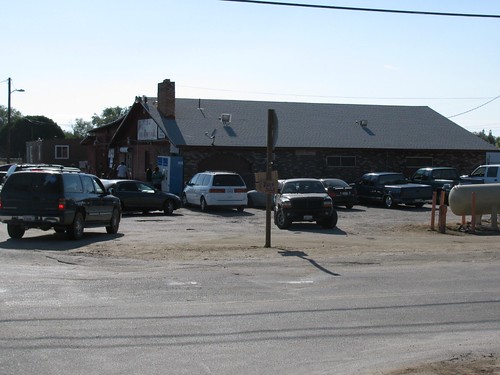
This is not the sort of downtown-to-downtown service that the Authority promised us.
There is an alternative. While the authority never considered a downtown Riverside station (and for good engineering reasons- turns out they need to build the system so that trains can pass through all but the termini at speed), they did consider two others in Riverside proper: one at Watkins and Blaine St. and one at I-215 and MLK. The one at Watkins and Blaine was removed from consideration due to expected community opposition- the University Neighbourhood Association killed a rather-minimal Metrolink station at the site, so an HSR station would probably be unthinkable- but the I-215/MLK station was removed for much shoddier reasons.
You see, both the Mayor and UCR's Executive Vice-Chancellor wrote letters to the Authority specifically requesting that the station be put at March Field. I don't know about the Mayor's reasoning, but UCR asked that the station be put at March Field instead because the UCR 20-year plan calls for PARKING STRUCTURES, not a high-speed rail station, around the overpass where the station would be.
Now, if I'm a student at UCR in 2031, when gas prices are so high that only the well-off can afford to drive, I wonder what would be more useful to me: a bunch of parking structures, or a high-speed rail link to the rest of the state? Also, while UCR has literally acres of land on which to build more parking, the HSR station can only go in a few places. If it's a choice between right on campus (full disclosure: literally steps from my office) and Mead Valley, I say we convince the campus to move their parking structures.
UPDATE: I should probably mention that the photos that weren't taken at the station site were taken on the bike ride to the site, as it is 1.5 miles from the nearest transit line (the 22).
View HSR in Riverside in a larger map
When we last left the HSR saga, the Riverside station was proposed for the Orangecrest neighbourhood of Riverside, at Alessandro and the I-215. The site was, shall we say, sub-optimal-- surrounded in every direction by single-family housing, much of it literally walled-off from the nearby streets. Also nearby is a large, typically suburban shopping centre, anchored by a K-Mart, and a trailhead for the Sycamore Canyon Wilderness Park. Not exactly a thriving, mixed-use urban paradise well-suited for an HSR station, which is why I opposed the site.
Bad enough, but it gets worse. You see, I went out to an open house put on by the Authority a few weeks ago, at the Orange Terrace Community Centre. The engineers have refined their station locations a bit more, and the old location was unsuitable for the station. Turns out that you can't built a station- or even track- off the end of a runway, so the train has to go below grade at Alessandro. So the engineers decided to move it down the track a bit... to here:
Yes, ladies and gentlemen, that is the proposed site of the new "Riverside" high-speed rail station. As you can see on the map above, it's not in Riverside, nor even Moreno Valley. It's in the unincorporated community of Mead Valley, just across the freeway from Perris. There is no transit nearby, no houses nearby, no meaningful commerce nearby- unless, of course, you'd like to buy surplus building materials or ship a few tons of air freight. Here's another view:
I even caught a few panoramic shots of the location, so you could see the abject nothingness of it all:
And, by the way, the site eschews the most populous and vibrant city in the Inland Empire for a community that looks like this:
Now, I mean no disrespect to those who live in rural communities, but this is not a place for a high-speed rail station. If you want to bring infrastructure here, try bringing sewers and gas lines- most residents are on septic tanks and have to purchase propane from the local general store. Oh, yeah, there's a local general store:
This is not the sort of downtown-to-downtown service that the Authority promised us.
There is an alternative. While the authority never considered a downtown Riverside station (and for good engineering reasons- turns out they need to build the system so that trains can pass through all but the termini at speed), they did consider two others in Riverside proper: one at Watkins and Blaine St. and one at I-215 and MLK. The one at Watkins and Blaine was removed from consideration due to expected community opposition- the University Neighbourhood Association killed a rather-minimal Metrolink station at the site, so an HSR station would probably be unthinkable- but the I-215/MLK station was removed for much shoddier reasons.
You see, both the Mayor and UCR's Executive Vice-Chancellor wrote letters to the Authority specifically requesting that the station be put at March Field. I don't know about the Mayor's reasoning, but UCR asked that the station be put at March Field instead because the UCR 20-year plan calls for PARKING STRUCTURES, not a high-speed rail station, around the overpass where the station would be.
Now, if I'm a student at UCR in 2031, when gas prices are so high that only the well-off can afford to drive, I wonder what would be more useful to me: a bunch of parking structures, or a high-speed rail link to the rest of the state? Also, while UCR has literally acres of land on which to build more parking, the HSR station can only go in a few places. If it's a choice between right on campus (full disclosure: literally steps from my office) and Mead Valley, I say we convince the campus to move their parking structures.
UPDATE: I should probably mention that the photos that weren't taken at the station site were taken on the bike ride to the site, as it is 1.5 miles from the nearest transit line (the 22).
Saturday, June 11, 2011
Transit-Friendly Flying
As you all are doubtlessly aware, Burbank-Bob Hope Airport is the only airport in the region directly served by rail. Metrolink and Amtrak both stop mere steps from the terminal. According to LAist, Jet Blue has decided to take advantage of that fact.
Your same-day JetBlue boarding pass is now good for a Metrolink ride to and from the airport. From what I can tell, that means "from anywhere in the system to/from the airport," but I'll edit this post when I have better information.
Sadly, JetBlue's main hub in the region is the Long Beach Municipal Airport. If you've never used it, it's a fantastic little airport- few passengers, short security lines, little delay- but it's one of the most difficult to get to on transit from the IE. Still, this provides some options for car-free travelers looking to get away.
Tuesday, June 7, 2011
It happens every time...
I write that I'll be away for a bit, and then I see something on the Internet and can't help but comment. Today, it's a piece from The New Republic on private-sector suburban jitneys. A jitney, for the unfamiliar, is something between a taxicab and a bus. They're usually privately-run, following a generally fixed route but able to deviate off that route in order to pick up or drop off passengers. The only place that I'm familiar with in the United States in which they're a common part of the transportation mix is in outer Queens, New York, but they are prevalent in many Asian cities and throughout the developing world. Peter McFerrin, at TNR, believes that they might be the solution to suburban transportation dilemmas.
I disagree, and here's why. McFerrin correctly identifies the problems facing suburban transit agencies and routes: low ridership, low farebox recovery, and high mileage. However, he doesn't get to the root of the problem- that suburban residents by and large own and use automobiles for mobility. It might matter a bit, around the margins, that a new bus on a route is able to detour into a neighbourhood in order to get passengers, but most people are going to continue to drive because that is the behaviour that is encouraged by both our society and our built infrastructure. As I've said before, it's not that the suburbs are impossible to navigate without a car (particularly if you own a bicycle and have some choice in your living situation), but driving in them is ridiculously easy. (As well, some places in the suburbs are more inconvenient than others- even crazy me probably couldn't survive in Eastvale long without access to a car.) So long as that remains the case, transit doesn't stand much of a chance. The area of innovation we need is not in transit service, but in the built environment.
Jitneys in the suburbs will also bring a whole host of new problems that conventional transit agencies don't face. First, they rarely adhere to a regular schedule- not a problem when you have enough demand for frequent headways, but a serious issue for infrequent, suburban routes.
Second, they lose the built-in advertising of the local transit agency. Most people around here know that the catchy little "Bus Stops Here" sign means that that point is connected to a broader transportation network. Many jitneys operate without signage at all, relying on the presence of vehicles to advertise service- and even if they did have signage, under the regulations proposed by the TNR article, a "University Avenue Jitney Stop" sign is much less informative about the service possibilities than an RTA bus stop sign. Further, is every jitney operator about to start up a web site, clearly listing routing, scheduling, and fare policies? I doubt it. People are wary enough about present transit.
Third, jitneys would be hard-pressed to follow an integrated fare policy. Your RTA pass is unlikely to be good on a private van, and the fare you pay on that van will probably not get you access to the RTA system. While I'm sure there are some users who would pay a higher fare to get around (myself included), most transit users in the suburbs are economically disadvantaged. Making them pay for a monthly bus pass (because they'll probably have to transfer to the regular transit system) AND round-trip jitney fare every day is probably going to be a big bite out of their budget.
Lastly, if a route is unprofitable for a suburban transit agency to run, when that agency needs only cover 20% or so of its costs at the farebox, it is unlikely to be profitable for a private operator, who must cover 100%+ of their costs at the farebox. While TNR suggests that such operations could realize significant fuel savings, it is labour, not fuel, that is the primary driver of costs in the transit sector. Most savings that would be realized would be from transforming decent-paying public-sector jobs into uncertain piece-work.
So, no, I don't think the jitney is a solution for the suburbs. I think it's a great fit for under-served parts of big cities, but the success of the model relies on the existence of a great deal of transit users trying to travel in an area. In the modern suburb, there just isn't a big enough transit user base- and it won't be the ephemeral jitney that creates that, it'll be a very conventional combination of dense land use and ordinary transit.
Subscribe to:
Posts (Atom)

